1990s Maps of Johns Ferry, Florida
Explore 1 historic maps of Johns Ferry from the 1990s. These maps offer a rare glimpse into what life looked like during the 1990s — showing old roads, neighborhoods, homes, and landmarks that have changed or disappeared over time.
Whether you're researching your family's past, planning a metal detecting trip, or studying how Johns Ferry's landscape evolved across the 1990s, these high-resolution maps are a powerful tool for exploring the history of this region.
- Focus on a specific era: All maps on this page are from the 1990s, giving you a focused view of this time period.
- See what’s changed: Compare century-old streets, trails, and buildings to today's modern landscape using overlays and satellite layers.
- Research with precision: Use these maps for genealogy, historical research, land use analysis, or educational projects.
- View, download, or print: Maps are fully viewable online in high resolution, and can be downloaded or printed for your own records.
Start exploring Johns Ferry's history through authentic maps from the 1990s. This is your window into the past.
Johns Ferry, FL maps
(1)- 1994 Map of Welaka, 1998 Print
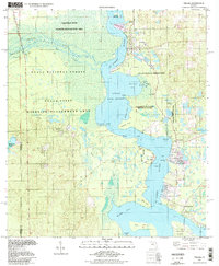 1994 Welaka1998 Print · USGSThe St. Johns riverfront and the northern reaches of Lake George come into focus in this late-twentieth-century study of Putnam County. Genealogists and local researchers can trace old river landings and settlements like Welaka, Norwalk, and the expansive Drayton Island.
End of results
Showing maps 1-1 of 1
Top cities near Johns Ferry
- Palatka historical maps
- Bunnell historical maps
- Pierson historical maps
- Crescent City historical maps
- Interlachen historical maps
- Pomona Park historical maps
See more
Frequently asked questions
- What are the different types of historical maps available for Johns Ferry?
- What is the oldest map of Johns Ferry?
- Where can I purchase historical maps of Johns Ferry for my home or office?
- Where can I download high-res historical maps of Johns Ferry?
- Are there historical topographic maps available for Johns Ferry?
- Is there historical aerial imagery available for Johns Ferry?
- Where are historical maps of Johns Ferry sourced from?