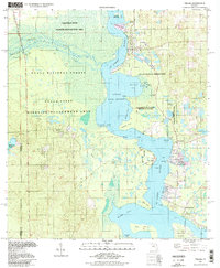
1994 Map of Welaka
USGS Topo · Published 1998About this map
The St Johns River and Little Lake George dominate this landscape on the border of Marion Co and Putnam Co. In the late 20th century, this region remained a significant hub for wildlife management and environmental study, evidenced by the expansive Welaka National Fish Hatchery and the University of Florida Research Center. The map documents the intricate riverine geography of the Oklawaha River confluence, where numerous points and coves like Beecher Point and Croaker Hole Cove define the shoreline. Small settlements such as Welaka, Fruitland, and Georgetown are situated along the eastern banks, while the western side is largely occupied by the Ocala National Forest and the Caravelle State Wildlife Management Area. Notable landmarks like Drayton Island and the secluded Welaka Springs illustrate the area's long-standing character as a river-based interior Florida community.
Find a feature on this map
42 named features on this map. Tap any name to fly to it.
Don’t see what you’re looking for? This feature index may not catch every label — zoom into the map to look around manually.
Map Details
Editions of this 1994 Welaka Map
This is the sole edition of this map. No revisions or reprints were ever made.
Other maps of this area

1912 · Palatka
USGS Topo · 1:48,000

1915 · Palatka
USGS Topo · 1:62,500

1915 · Interlachen
USGS Topo · 1:48,000

1916 · Interlachen
USGS Topo · 1:62,500

1944 · Interlachen
USGS Topo · 1:62,500

1949 · Rodman
USGS Topo · 1:24,000

1949 · Interlachen
USGS Topo · 1:62,500

1954 · Daytona Beach
USGS Topo · 1:250,000

1958 · Daytona Beach
USGS Topo · 1:250,000

1964 · Daytona Beach
USGS Topo · 1:250,000