1970s Maps of Fort Pierce, Saint Lucie County
Explore 2 historic maps of Fort Pierce from the 1970s. These maps offer a rare glimpse into what life looked like during the 1970s — showing old roads, neighborhoods, homes, and landmarks that have changed or disappeared over time.
Whether you're researching your family's past, planning a metal detecting trip, or studying how Fort Pierce's landscape evolved across the 1970s, these high-resolution maps are a powerful tool for exploring the history of this region.
- Focus on a specific era: All maps on this page are from the 1970s, giving you a focused view of this time period.
- See what’s changed: Compare century-old streets, trails, and buildings to today's modern landscape using overlays and satellite layers.
- Research with precision: Use these maps for genealogy, historical research, land use analysis, or educational projects.
- View, download, or print: Maps are fully viewable online in high resolution, and can be downloaded or printed for your own records.
Start exploring Fort Pierce's history through authentic maps from the 1970s. This is your window into the past.
Fort Pierce, Saint Lucie County maps
(2)- 1972 Map of Fort Pierce
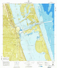 1972 Fort Pierce1972 Print · USGSFort Pierce and the Indian River shoreline are captured in detail during the early seventies, showcasing a landscape of barrier islands and emerging infrastructure. Trace the early layout of Paradise Park or locate landmarks like the Fort Pierce Causeway and the Florida East Coast Railroad.
 - 1972 Map of Fort Pierce, 1975 Print
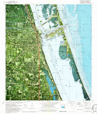 1972 Fort Pierce1975 Print · USGSThe Florida Treasure Coast comes into focus in the early seventies as the urban grid of Fort Pierce expands toward the sea. Researchers can trace the legacy of coastal engineering along the Intracoastal Waterway and locate landmarks like the Florida East Coast rail line and Paradise Park.2 unique versions available
End of results
Showing maps 1-2 of 2
Frequently asked questions
- What are the different types of historical maps available for Fort Pierce?
- What is the oldest map of Fort Pierce?
- Where can I purchase historical maps of Fort Pierce for my home or office?
- Where can I download high-res historical maps of Fort Pierce?
- Are there historical topographic maps available for Fort Pierce?
- Is there historical aerial imagery available for Fort Pierce?
- Where are historical maps of Fort Pierce sourced from?