Loading...
Loading map...1972 Map of Fort Pierce
USGS Topo · Published 1972About this map
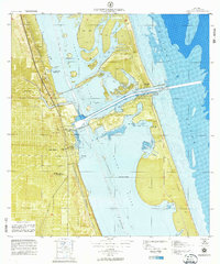
Fort Pierce and its intricate coastal geography are the focus of this 1972 prototype survey, illustrating the complex relationship between the mainland and the barrier islands during a period of significant local development. The Florida East Coast Railroad runs parallel to the coastline, serving as a primary transit artery west of Moore Creek, while the Intracoastal Waterway carves a deep-water path through the Indian River.
Find a feature on this map
36 named features on this map. Tap any name to fly to it.
Don’t see what you’re looking for? This feature index may not catch every label — zoom into the map to look around manually.
Map Details
Date Portrayed1972
Date Published1972
PublisherU.S. Geological Survey
Map TypeTopographic
Scale1:10,000
Physical Dimensions36 x 43.2 inches
Editions of this 1972 Fort Pierce Map
This is the sole edition of this map. No revisions or reprints were ever made.
Historical Maps of Fort Pierce Through Time
1 maps found
Featured Locations
Source Details
SourceU.S. Geological Survey
CopyrightPublic Domain