
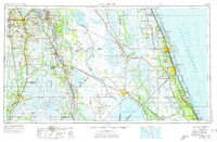
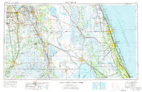
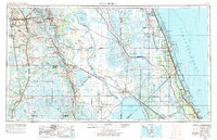
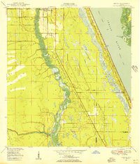
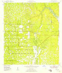
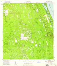
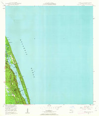
1956 Map of Fort Pierce
USGS Topo · Published 1965About this map
Lake Okeechobee and the sweeping wetlands of the central Florida peninsula dominate this mid-century landscape, illustrating a region defined by its vast interior waters and emerging coastal corridors. The map highlights the significant military and aviation presence of the era, notably the Avon Park AFB and its extensive AF Range, alongside the Sebring Air Terminal. In the west, the phosphate mining industry is visible through the Tailings pond features near Bartow. Transport networks are in a state of transition, as the long-established Atlantic Coast Line and Seaboard Air Line railroads are joined by the newly developing Sunshine State Parkway. From the quiet interior of the Brighton Indian Reservation to the barrier islands of Hutchinson Island and Jupiter Island, the survey documents a balance between protected lands like Highlands Hammock State Park and the growing citrus and cattle country of the ridge.
Find a feature on this map
121 named features on this map. Tap any name to fly to it.
Don’t see what you’re looking for? This feature index may not catch every label — zoom into the map to look around manually.
Map Details
Editions of this 1956 Fort Pierce Map
4 editions found
Other maps of this area

1944 · Plant City
USGS Topo · 1:31,680

1944 · Lakeland
USGS Topo · 1:31,680

1944 · Auburndale
USGS Topo · 1:31,680

1948 · Palm City
USGS Topo · 1:24,000
1948 · Ankona
USGS Topo · 1:24,000
1948 · Rood
USGS Topo · 1:24,000

1948 · St. Lucie Inlet
USGS Topo · 1:24,000
1948 · Gomez
USGS Topo · 1:24,000
1948 · Hobe Sound
USGS Topo · 1:24,000

1948 · Jupiter
USGS Topo · 1:24,000