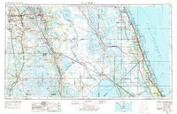
1956 Map of Fort Pierce
USGS Topo · Published 1984About this map
Lake Okeechobee anchors the southern landscape of this mid-century Florida survey, which spans from the citrus-growing interior to the Atlantic Ocean coast. The interior is defined by a vast network of water bodies, including Lake Kissimmee and Lake Istokpoga, separated by the citrus groves and ridge lands surrounding Sebring and Lake Wales. Along the eastern shore, the barrier of Hutchinson Island shields the Indian River, where communities like Vero Beach and Fort Pierce are connected by the Florida East Coast railway.
Find a feature on this map
72 named features on this map. Tap any name to fly to it.
Don’t see what you’re looking for? This feature index may not catch every label — zoom into the map to look around manually.
Map Details
Editions of this 1956 Fort Pierce Map
4 editions found

Other maps of this area

1944 · Plant City
USGS Topo · 1:31,680

1944 · Lakeland
USGS Topo · 1:31,680

1944 · Auburndale
USGS Topo · 1:31,680

1948 · Palm City
USGS Topo · 1:24,000

1948 · Ankona
USGS Topo · 1:24,000

1948 · Rood
USGS Topo · 1:24,000

1948 · St. Lucie Inlet
USGS Topo · 1:24,000

1948 · Gomez
USGS Topo · 1:24,000

1948 · Hobe Sound
USGS Topo · 1:24,000

1948 · Jupiter
USGS Topo · 1:24,000