1940s Maps of Gulf Breeze, Florida
Explore 6 historic maps of Gulf Breeze from the 1940s. These maps offer a rare glimpse into what life looked like during the 1940s — showing old roads, neighborhoods, homes, and landmarks that have changed or disappeared over time.
Whether you're researching your family's past, planning a metal detecting trip, or studying how Gulf Breeze's landscape evolved across the 1940s, these high-resolution maps are a powerful tool for exploring the history of this region.
- Focus on a specific era: All maps on this page are from the 1940s, giving you a focused view of this time period.
- See what’s changed: Compare century-old streets, trails, and buildings to today's modern landscape using overlays and satellite layers.
- Research with precision: Use these maps for genealogy, historical research, land use analysis, or educational projects.
- View, download, or print: Maps are fully viewable online in high resolution, and can be downloaded or printed for your own records.
Start exploring Gulf Breeze's history through authentic maps from the 1940s. This is your window into the past.
Gulf Breeze, FL maps
(6)- 1941 Map of Pensacola, 1956 Print
 1941 Pensacola1956 Print · USGSPensacola and its surrounding bays are seen here just before the mid-century boom, detailing a landscape defined by naval aviation and maritime rail. Trace the historic city grid, explore the U S Naval Reservation, or locate Oakland Ch and Black Hammock Cem.
 - 1942 Map of Pensacola
 1942 Pensacola1942 Print · USGSCoastal Florida is captured here in the early years of the war, showing the maritime and rail infrastructure that shaped the Panhandle. Genealogists and historians can trace family locations near Oakland Ch, the Black Hammock Cem, and the busy Muscogee Wharf.2 unique versions available
 - 1944 Map of Oriole Beach
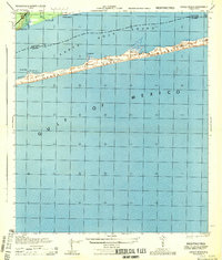 1944 Oriole Beach1944 Print · USGSThe Florida Panhandle's barrier islands remain largely undeveloped during the mid-1940s, dominated by the Santa Rosa National Monument. Local historians can trace early maritime markers and coastal settlements like Oriole Beach and the U S Naval Res.
 - 1944 Map of Gulf Breeze
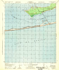 1944 Gulf Breeze1944 Print · USGSCoastal Florida and its military defenses are surveyed here during the mid-forties, showing the transition from naval outposts to early recreation. Researchers can trace the layout of the U S Naval Reservation and find the location of the Pensacola Quarantine Station (Abandoned) or the old Casino.
 - 1944 Map of Garcon Point
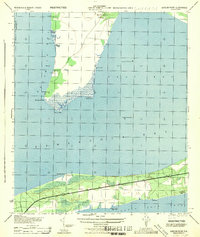 1944 Garcon Point1944 Print · USGSThe Santa Rosa County coastline and the Garcon Point peninsula are captured here during the mid-forties. Genealogists and local historians can trace the early development of Woodlawn Beach or locate the northern Black Hammock Cem and several 1930s benchmarks.
 - 1944 Map of Pensacola
 1944 Pensacola1944 Print · USGSWorld War II era Pensacola reveals a bustling harbor defined by industrial piers and emerging suburbs. Trace the waterfront rail terminals like L & N Railroad Piers and follow the bluffs past Magnolia Bluff to the Bohemia Brick Chimney.
End of results
Showing maps 1-6 of 6
Top cities near Gulf Breeze
Frequently asked questions
- What are the different types of historical maps available for Gulf Breeze?
- What is the oldest map of Gulf Breeze?
- Where can I purchase historical maps of Gulf Breeze for my home or office?
- Where can I download high-res historical maps of Gulf Breeze?
- Are there historical topographic maps available for Gulf Breeze?
- Is there historical aerial imagery available for Gulf Breeze?
- Where are historical maps of Gulf Breeze sourced from?