1900s (20th Century) Maps of Indian Ford, Florida
Explore 9 historic maps of Indian Ford from the 1900s (20th Century). These maps offer a rare glimpse into what life looked like during the 1900s — showing old roads, neighborhoods, homes, and landmarks that have changed or disappeared over time.
Whether you're researching your family's past, planning a metal detecting trip, or studying how Indian Ford's landscape evolved across the 1900s, these high-resolution maps are a powerful tool for exploring the history of this region.
- Focus on a specific era: All maps on this page are from the 1900s, giving you a focused view of this time period.
- See what’s changed: Compare century-old streets, trails, and buildings to today's modern landscape using overlays and satellite layers.
- Research with precision: Use these maps for genealogy, historical research, land use analysis, or educational projects.
- View, download, or print: Maps are fully viewable online in high resolution, and can be downloaded or printed for your own records.
Start exploring Indian Ford's history through authentic maps from the 1900s. This is your window into the past.
Indian Ford, FL maps
(9)- 1934 Map of Harold
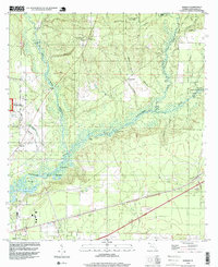
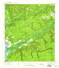 1934 Harold1934 Print · USGSSanta Rosa County and the Florida Panhandle are shown here in the 1930s, defined by the winding paths of the Blackwater and Yellow Rivers. Researchers can locate family landmarks like the Old Whitmier Place, Kellys Mill, and several river access points including Faulks Ferry Landing.3 unique versions available
 - 1937 Map of Harold, 1942 Print
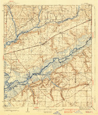 1937 Harold1942 Print · USGSSanta Rosa County's river-and-rail landscape is captured here in the mid-1930s, showing a world of timber landings and rural parishes. Trace family history through Pleasant Home Ch, find the Old Whitmier Place, or locate Faulks Ferry Landing along the Yellow River.
 - 1938 Map of Harold
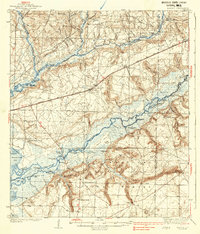 1938 Harold1938 Print · USGSThe Florida panhandle comes alive in the late 1930s, showing a timber-and-rail landscape shaped by the Blackwater River. Genealogists and historians can trace family roots at Old Whitmier Place, Flowers Field Cemetery, and several rural churches like Welcome Ch.4 unique versions available
 - 1957 Map of Pensacola, 1967 Print
 1957 Pensacola1967 Print · USGSThe Florida Panhandle and Alabama coast are seen here at the height of the Cold War, showcasing a unique mix of military aviation and emerging beach tourism. Genealogists and local historians can trace legacy sites like Old Corry Field, the lumber town of Bagdad, and the coastal reaches of Santa Rosa Island.3 unique versions available
 - 1959 Map of Pensacola
 1959 Pensacola1959 Print · USGSThe Florida Panhandle and Alabama coast come alive in this late fifties survey of military aviation and maritime life. Genealogists can trace family roots in Bagdad, Loxley, and Milton while mapping the rails of the Louisville and Nashville.
 - 1960 Map of Pensacola
 1960 Pensacola1960 Print · USGSThe Florida Panhandle and Alabama's eastern shore are shown during a period of rapid military and coastal growth. Genealogists and historians can trace the mid-century footprints of Warrington, the Pensacola NAS (Chevalier), and the Blackwater River timber lands.
 - 1973 Map of Harold, 1976 Print
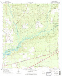 1973 Harold1976 Print · USGSIn the early 1970s, this portion of Santa Rosa County was a landscape defined by the winding Blackwater River and the operations of the Whiting Field U S Naval Air Sta. Researchers can trace old routes along the Louisville and Nashville tracks and locate community sites like Harold and Pleasant Home Ch.2 unique versions available
 - 1978 Map of Crestview, 1982 Print
 1978 Crestview1982 Print · USGSThe Florida Panhandle and southern Alabama borderlands appear here in the late seventies as the military and timber industries shaped the landscape. Genealogists can trace family roots through small settlements like Cannon Town or Svea, and locate old sites like Aux Field No 4 (Abandoned).2 unique versions available
 - 1994 Map of Harold, 1999 Print
 1994 Harold1999 Print · USGSSanta Rosa County in the mid-1990s was a hub of naval aviation and river-based conservation. Genealogists and historians can trace local landmarks like Pleasant Home Ch, the community of Harold, and the extensive Blackwater River State Forest.
End of results
Showing maps 1-9 of 9
Top cities near Indian Ford
Frequently asked questions
- What are the different types of historical maps available for Indian Ford?
- What is the oldest map of Indian Ford?
- Where can I purchase historical maps of Indian Ford for my home or office?
- Where can I download high-res historical maps of Indian Ford?
- Are there historical topographic maps available for Indian Ford?
- Is there historical aerial imagery available for Indian Ford?
- Where are historical maps of Indian Ford sourced from?