1940s Maps of Venice, Florida
Explore 5 historic maps of Venice from the 1940s. These maps offer a rare glimpse into what life looked like during the 1940s — showing old roads, neighborhoods, homes, and landmarks that have changed or disappeared over time.
Whether you're researching your family's past, planning a metal detecting trip, or studying how Venice's landscape evolved across the 1940s, these high-resolution maps are a powerful tool for exploring the history of this region.
- Focus on a specific era: All maps on this page are from the 1940s, giving you a focused view of this time period.
- See what’s changed: Compare century-old streets, trails, and buildings to today's modern landscape using overlays and satellite layers.
- Research with precision: Use these maps for genealogy, historical research, land use analysis, or educational projects.
- View, download, or print: Maps are fully viewable online in high resolution, and can be downloaded or printed for your own records.
Start exploring Venice's history through authentic maps from the 1940s. This is your window into the past.
Venice, FL maps
(5)- 1943 Map of Laurel, 1961 Print
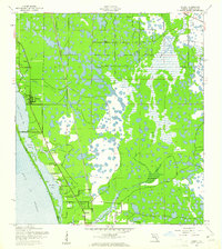 1943 Laurel1961 Print · USGSSarasota County's coastal landscape appears in the early 1940s as a network of rail-side settlements and tidal bays. Genealogists can trace family footprints near Laurel Sch or along the Seaboard Air Line and Casey Key.
 - 1944 Map of Lower Myakka Lake
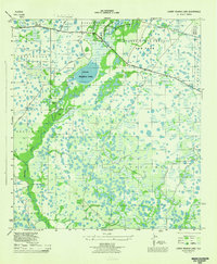 1944 Lower Myakka Lake1944 Print · USGSSarasota County's interior is captured here in the mid-1940s, highlighting the wild wetlands and early state parkland. Genealogists and historians can locate vanished outposts like Shiney Town and Harris Camp or trace the early path of the Atlantic Coast Line.2 unique versions available
 - 1944 Map of Myakka River
 1944 Myakka River1944 Print · USGSSarasota County during the mid-forties is depicted as a landscape of river marshes and military training grounds. Genealogists and historians can trace old roads like Jackson Road and locate the wartime Bombing Area or Evans Fishing Camp.2 unique versions available
 - 1944 Map of Laurel
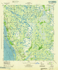 1944 Laurel1944 Print · USGSCoastal Sarasota County is seen here during the mid-forties, balancing its identity as a fishing and transport hub with wartime military needs. Genealogists and local historians can trace the foundations of Laurel through the Laurel Sch and Laurel Chapel, or locate the expansive U S Army Bombing Area.
 - 1944 Map of Venice
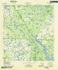
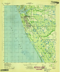 1944 Venice1944 Print · USGSCoastal Sarasota County is captured here during the height of the Second World War as military operations expanded along the Gulf. Researchers can trace the layout of the Venice Army Air Base and locate local landmarks like St Marks Church and the Kentucky Military Institute.3 unique versions available
End of results
Showing maps 1-5 of 5
Top cities near Venice
- North Port historical maps
- Sarasota historical maps
- Englewood historical maps
- South Venice historical maps
- Laurel historical maps
- Rotonda historical maps
See more
Top neighborhoods of Venice
Frequently asked questions
- What are the different types of historical maps available for Venice?
- What is the oldest map of Venice?
- Where can I purchase historical maps of Venice for my home or office?
- Where can I download high-res historical maps of Venice?
- Are there historical topographic maps available for Venice?
- Is there historical aerial imagery available for Venice?
- Where are historical maps of Venice sourced from?