1970s Maps of Venice, Florida
Explore 6 historic maps of Venice from the 1970s. These maps offer a rare glimpse into what life looked like during the 1970s — showing old roads, neighborhoods, homes, and landmarks that have changed or disappeared over time.
Whether you're researching your family's past, planning a metal detecting trip, or studying how Venice's landscape evolved across the 1970s, these high-resolution maps are a powerful tool for exploring the history of this region.
- Focus on a specific era: All maps on this page are from the 1970s, giving you a focused view of this time period.
- See what’s changed: Compare century-old streets, trails, and buildings to today's modern landscape using overlays and satellite layers.
- Research with precision: Use these maps for genealogy, historical research, land use analysis, or educational projects.
- View, download, or print: Maps are fully viewable online in high resolution, and can be downloaded or printed for your own records.
Start exploring Venice's history through authentic maps from the 1970s. This is your window into the past.
Venice, FL maps
(6)- 1972 Map of Tampa, 1974 Print
 1972 Tampa1974 Print · USGSThe Florida Gulf Coast appears in a period of significant growth during the early seventies, from the urban centers of the bay to the quiet southern keys. Researchers can trace the expansion of St Petersburg or locate family sites near Safety Harbor, Valrico, and Boca Ciega.
 - 1973 Map of Venice, 1974 Print
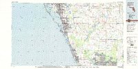
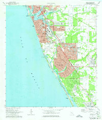 1973 Venice1974 Print · USGSSarasota County's coastal growth is captured in the early seventies, as residential developments expanded inland from the Gulf. Genealogists and local historians can trace family-named landmarks and institutions like St Marks Ch, the Venice High Sch, and Gulf Pines Memorial Park.3 unique versions available
 - 1973 Map of Lower Myakka Lake, 1974 Print
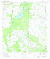 1973 Lower Myakka Lake1974 Print · USGSSarasota County's freshwater wetlands and river systems are documented in the early seventies, centered on the Myakka River State Park. Researchers can locate old outposts like Harris Camp and Shiney Town, or trace the Myakka River down to Deep Hole.
 - 1973 Map of Myakka River, 1975 Print
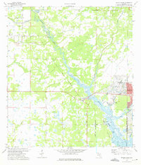 1973 Myakka River1975 Print · USGSSarasota and Charlotte counties were beginning to see significant residential transformation in the early seventies. Genealogists and historians can trace the early footprints of North Port, the medicinal waters of Warm Mineral Springs, and landmarks like Tarpon Point.2 unique versions available
 - 1973 Map of Laurel, 1975 Print
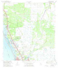 1973 Laurel1975 Print · USGSSarasota County's coastal settlements and barrier islands are captured here during a period of significant mid-century growth. Researchers can trace the development of Osprey, Laurel, and Nokomis alongside landmarks like the Drive-in Theater and Nokomis Ch.3 unique versions available
 - 1979 Map of Sarasota, 1980 Print
 1979 Sarasota1980 Print · USGSCoastal Florida in the late seventies reveals the rapid growth of the Gulf shoreline from Bradenton down to Port Charlotte. Trace the expansion of coastal communities like Bayshore Gardens, find long-standing landmarks like Trailer Estates, or explore the vast preserve of Myakka River State Park.
End of results
Showing maps 1-6 of 6
Top cities near Venice
- North Port historical maps
- Sarasota historical maps
- Englewood historical maps
- South Venice historical maps
- Laurel historical maps
- Rotonda historical maps
See more
Top neighborhoods of Venice
Frequently asked questions
- What are the different types of historical maps available for Venice?
- What is the oldest map of Venice?
- Where can I purchase historical maps of Venice for my home or office?
- Where can I download high-res historical maps of Venice?
- Are there historical topographic maps available for Venice?
- Is there historical aerial imagery available for Venice?
- Where are historical maps of Venice sourced from?