Old Maps of Taylor County, Florida for Hiking & Exploration
Hike through history with 198 historic maps of Taylor County. Explore old trails, ghost towns, and forgotten backroads — perfect for outdoor adventurers and local explorers.
- Rediscover forgotten places: Map out old mining camps, roads, and footpaths that no longer exist on modern maps.
- Layer with modern tools: Combine with LiDAR or satellite views to plan hikes through historical terrain.
- Made for exploration: Popular among hikers, overlanders, and local history lovers.
Use these maps to find adventure and explore the hidden past of Taylor County.
Taylor County, FL maps
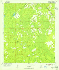
(198)- 1952 Map of Secotan, 1973 Print
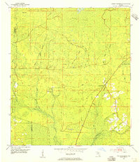
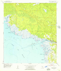
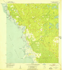
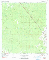 1952 Secotan1973 Print · USGSTaylor County forest lands and wetlands are documented here in the early fifties, showing the region before modern development. Researchers can trace the Atlantic Coast Line railroad and locate the Secotan settlement and Secotan Lookout Tower.
 - 1954 Map of Fenholloway, 1955 Print
 1954 Fenholloway1955 Print · USGSFlorida's coastal wetlands are preserved here in the mid-1950s, showing the intersection of timber-country rail and vast cypress sogs. Trace the Southern railroad line past Fenholloway to find Foley Lookout Tower and the remote reaches of Blue Sog.3 unique versions available
 - 1954 Map of Day SE, 1955 Print
 1954 Day SE1955 Print · USGSLafayette and Taylor Counties are shown in the mid-fifties as a landscape of interconnected wetlands and timber camps. Genealogists can locate family names at Folsom Cem and Brown Cem, or trace the remote reaches of San Pedro Bay.3 unique versions available
 - 1954 Map of Clara, 1955 Print
 1954 Clara1955 Print · USGSThe Florida Big Bend country in the mid-1950s is defined by its wild river systems and the reach of the Atlantic Coast Line railroad. Local historians can trace the small settlements of Clara and Tennille alongside landmarks like Steinhatchee Spring and Iron Spring.3 unique versions available
 - 1954 Map of Salem SW, 1955 Print
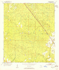
 1954 Salem SW1955 Print · USGSThe Taylor County interior in the mid-1950s was a landscape defined by timber rail lines and unique karst features. Genealogists and researchers can trace the path of the Atlantic Coast Line or locate the Salem Lookout Tower and California Sinks.4 unique versions available
 - 1954 Map of Johnson Hammock, 1955 Print
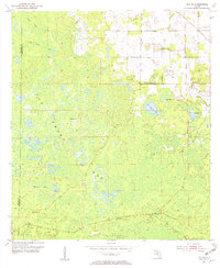
 1954 Johnson Hammock1955 Print · USGSCoastal Taylor County in the mid-1950s is a landscape of winding waterways and remote pine flatlands. Genealogists and local historians can trace the area's rural character through landmarks like Oakland Ch and the meandering paths of the Econfina River and Johnson Hammock Creek.3 unique versions available
 - 1954 Map of Day, 1955 Print
 1954 Day1955 Print · USGSLafayette County was a landscape of rail-connected hamlets and expansive cypress bays in the mid-1950s. Researchers can locate family landmarks like the Roger Cem and Dees Cem, or trace the old Southern rail line through Day and Mayo Junction.3 unique versions available
 - 1954 Map of Jena, 1955 Print
 1954 Jena1955 Print · USGSThe coastal forest and wetlands of Dixie County are documented here in the mid-1950s as modern roads began to replace old timber routes. You can trace the Steinhatchee River boundary or locate family sites like Jena School, Mingos Cemetery, and the settlement of Jonesboro.3 unique versions available
 - 1954 Map of Cooks Hammock, 1955 Print
 1954 Cooks Hammock1955 Print · USGSLafayette and Taylor counties meet in this mid-century survey of the Florida interior during a time when timber and wetlands defined the local economy. Trace the path of the Old Railroad Grade and locate landmarks like Cooks Hammock and the Carbur Lookout Tower.3 unique versions available
 - 1954 Map of Warrior Swamp, 1955 Print
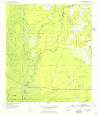
 1954 Warrior Swamp1955 Print · USGSTaylor County's wetlands are surveyed here in the mid-1950s, revealing a landscape of timber-era camps and remote burial grounds. Trace the paths of an Old Railroad Grade near Huxford Camp or locate the Sandhill Cem and Sealey Cem.2 unique versions available
 - 1954 Map of Salem, 1955 Print
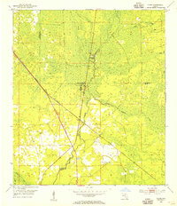
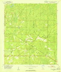
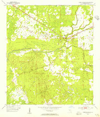
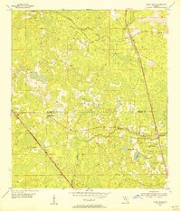
 1954 Salem1955 Print · USGSIn mid-century Taylor County, the rail line was the lifeblood connecting small coastal plain communities. Genealogists and historians can trace the foundations of local life at Athena Ch, Salem Cem, and the stations along the ATLANTIC COAST LINE.3 unique versions available
 - 1954 Map of Boyd, 1955 Print
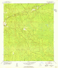
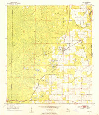
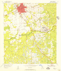
 1954 Boyd1955 Print · USGSTaylor County in the mid-fifties is captured here as the timber industry and rail networks defined the landscape around Perry. Genealogists and local historians can trace rural congregations at Shiloh Ch and Pisgah Ch or locate the old Landing Field near Boyd.2 unique versions available
 - 1954 Map of Steinhatchee, 1955 Print
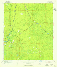
 1954 Steinhatchee1955 Print · USGSThe Florida Gulf Coast near the Taylor and Dixie county line is shown here in the mid-1950s, centered on the riverfront at Steinhatchee. Local historians can trace old coastal access points like Dallus Creek Landing and the winding reaches of Pine Log Swamp.4 unique versions available
 - 1954 Map of Hampton Springs, 1955 Print
 1954 Hampton Springs1955 Print · USGSTaylor County's marshy lowlands and river systems are captured in the mid-fifties, showing the region's industrial and natural balance. Local researchers can trace an Old Railroad Grade or find the remote Poorspot Cem and Waldo Spring.3 unique versions available
 - 1954 Map of Secotan, 1955 Print
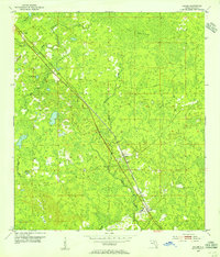
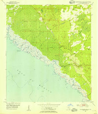
 1954 Secotan1955 Print · USGSNorth Florida's timber and rail landscape is captured here in the mid-fifties, centered on the settlement of Secotan. Local historians can trace the path of the Atlantic Coast Line railroad and locate landmarks like the Secotan Lookout Tower.3 unique versions available
 - 1954 Map of Day NW, 1955 Print
 1954 Day NW1955 Print · USGSTaylor County wetlands appear in their mid-century state just after the Korean War, showing a landscape defined by water and woods. Genealogists and historians can trace the Southern rail line and the natural winding path of the Fenholloway River through San Pedro Bay.3 unique versions available
 - 1954 Map of Keaton Beach, 1956 Print
 1954 Keaton Beach1956 Print · USGSCoastal Taylor County comes into focus in the mid-fifties, showing a landscape of tidal marshes and early waterfront outposts. Trace the locations of Dekle Beach and Keaton Beach, or follow the Old Railroad Grade and named landmarks like Howell Place.3 unique versions available
 - 1954 Map of Okefenokee Slough, 1956 Print
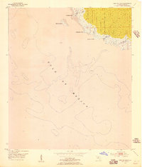
 1954 Okefenokee Slough1956 Print · USGSThe Taylor County coastline in the mid-1950s is a patchwork of tidal creeks and remote camps along the Gulf of Mexico. Genealogists and historians can locate old landings and outposts like Spring Warrior Camp, Ezell Camp, and Adams Beach connected by a historic Old Railroad Grade.2 unique versions available
 - 1954 Map of Crooked Point, 1956 Print
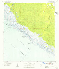
 1954 Crooked Point1956 Print · USGSThe Taylor County coastline is captured here in the mid-1950s as a wild expanse of tidal marshes and timber flats. Genealogists and historians can trace the Old Railroad Grade and locate the small settlement at Fishermans Rest along the shore.2 unique versions available
 - 1954 Map of Gainesville, 1965 Print
 1954 Gainesville1965 Print · USGSMid-century North Central Florida comes into focus as a landscape of timber, rails, and river towns along the Gulf. Trace family roots in established centers like Gainesville or follow the path of the Suwannee River to the coastal docks of Cedar Key.3 unique versions available
 - 1954 Map of Valdosta, 1967 Print
 1954 Valdosta1967 Print · USGSThe South Georgia and North Florida borderlands are captured here in the mid-fifties, showing the deep timber and wetland networks of the coastal plain. Researchers can trace the path of the Atlantic Coast Line through Valdosta or explore the interior of the Okefenokee Swamp.2 unique versions available
 - 1955 Map of Snipe Island, 1956 Print
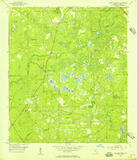
 1955 Snipe Island1956 Print · USGSThe Florida Big Bend coast is captured in the mid-fifties as a wilderness of tidal creeks and river deltas at the Jefferson and Taylor county line. Genealogists and historians can trace the remote Econfina Landing and named coastal landmarks like Snipe Island and Gamble Point.5 unique versions available
 - 1955 Map of Perry, 1956 Print
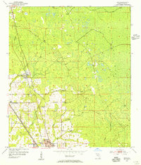
 1955 Perry1956 Print · USGSMid-century Perry and the industrial settlement at Foley are shown here just as the rail-and-timber economy was maturing. Researchers can locate numerous family-named landmarks like Wilcox Cem, Lakeside Ch, and the rail crossing at Bucell Junction.3 unique versions available
 - 1955 Map of Shady Grove, 1956 Print
 1955 Shady Grove1956 Print · USGSMadison and Taylor counties in the mid-1950s reveal a landscape of timber-dependent rail stops and rural homesteads. Genealogists can locate family landmarks like Tuten Cemetery, Pleasant Grove Church, and the community of Eridu.4 unique versions available
 - 1955 Map of Nutall Rise, 1956 Print
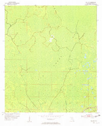
 1955 Nutall Rise1956 Print · USGSThe Florida Big Bend region at the Jefferson and Taylor county line is a landscape of river confluences and timber history in the mid-1950s. Genealogists and historians can trace the paths of an Old Railroad Grade and locate long-standing settlements like Nutall Rise, Scanlon, and Cabbage Grove.3 unique versions available
Showing maps 1-25 of 198
Top cities of Taylor County
Frequently asked questions
- What are the different types of historical maps available for Taylor County?
- What is the oldest map of Taylor County?
- Where can I purchase historical maps of Taylor County for my home or office?
- Where can I download high-res historical maps of Taylor County?
- Are there historical topographic maps available for Taylor County?
- Is there historical aerial imagery available for Taylor County?
- Where are historical maps of Taylor County sourced from?