1960s Maps of Guilford, Florida
Explore 1 historic maps of Guilford from the 1960s. These maps offer a rare glimpse into what life looked like during the 1960s — showing old roads, neighborhoods, homes, and landmarks that have changed or disappeared over time.
Whether you're researching your family's past, planning a metal detecting trip, or studying how Guilford's landscape evolved across the 1960s, these high-resolution maps are a powerful tool for exploring the history of this region.
- Focus on a specific era: All maps on this page are from the 1960s, giving you a focused view of this time period.
- See what’s changed: Compare century-old streets, trails, and buildings to today's modern landscape using overlays and satellite layers.
- Research with precision: Use these maps for genealogy, historical research, land use analysis, or educational projects.
- View, download, or print: Maps are fully viewable online in high resolution, and can be downloaded or printed for your own records.
Start exploring Guilford's history through authentic maps from the 1960s. This is your window into the past.
Guilford, FL maps
(1)- 1966 Map of Lulu, 1967 Print
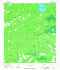 1966 Lulu1967 Print · USGSFlorida's interior timberlands come into focus in the mid-1960s, showing the rural rail corridor between Lulu and Cliftonville. Genealogists can locate Gillen-Allen Cem, Oak Grove Ch, and the isolated turpentine site at Shaws Still near Swift Creek.2 unique versions available
End of results
Showing maps 1-1 of 1
Top cities near Guilford
- Lake City historical maps
- Alachua historical maps
- High Springs historical maps
- Lake Butler historical maps
- Brooker historical maps
- Worthington Springs historical maps
See more
Frequently asked questions
- What are the different types of historical maps available for Guilford?
- What is the oldest map of Guilford?
- Where can I purchase historical maps of Guilford for my home or office?
- Where can I download high-res historical maps of Guilford?
- Are there historical topographic maps available for Guilford?
- Is there historical aerial imagery available for Guilford?
- Where are historical maps of Guilford sourced from?