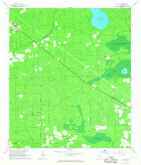
1966 Map of Lulu
USGS Topo · Published 1967About this map
The Southern railroad corridor anchors this mid-century view of the Florida interior, connecting the communities of Lulu, Guilford, and Cliftonville across a landscape of cypress swamps and pine flatwoods. The map reveals a rural economy shaped by timber and naval stores, evidenced by the presence of Shaws Still and a dedicated Lookout Tower monitoring the surrounding timberlands. For genealogists, the sheet preserves the locations of several community landmarks, including Gillen-Allen Cem, Douglas Cem, and New Zion Cem, alongside Oak Grove Ch and Midway Ch. Hydrographic features like Palestine Lake, Olustee Creek, and Swift Creek define the drainage patterns of the area, while the boundary between Columbia and Union Counties cuts through the swampy terrain of South Prong Swamp and Center Bay.
Find a feature on this map
22 named features on this map. Tap any name to fly to it.
Don’t see what you’re looking for? This feature index may not catch every label — zoom into the map to look around manually.
Map Details
Editions of this 1966 Lulu Map
2 editions found
Other maps of this area

1954 · Gainesville
USGS Topo · 1:250,000

1954 · Valdosta
USGS Topo · 1:250,000

1958 · Valdosta
USGS Topo · 1:250,000

1958 · Gainesville
USGS Topo · 1:250,000

1959 · Valdosta
USGS Topo · 1:250,000

1959 · Gainesville
USGS Topo · 1:250,000

1962 · Lake City East
USGS Topo · 1:24,000

1962 · Mikesville
USGS Topo · 1:24,000

1963 · Olustee
USGS Topo · 1:24,000

1963 · Sanderson South
USGS Topo · 1:24,000