1900s (20th Century) Maps of New Smyrna Beach, Florida
Explore 9 historic maps of New Smyrna Beach from the 1900s (20th Century). These maps offer a rare glimpse into what life looked like during the 1900s — showing old roads, neighborhoods, homes, and landmarks that have changed or disappeared over time.
Whether you're researching your family's past, planning a metal detecting trip, or studying how New Smyrna Beach's landscape evolved across the 1900s, these high-resolution maps are a powerful tool for exploring the history of this region.
- Focus on a specific era: All maps on this page are from the 1900s, giving you a focused view of this time period.
- See what’s changed: Compare century-old streets, trails, and buildings to today's modern landscape using overlays and satellite layers.
- Research with precision: Use these maps for genealogy, historical research, land use analysis, or educational projects.
- View, download, or print: Maps are fully viewable online in high resolution, and can be downloaded or printed for your own records.
Start exploring New Smyrna Beach's history through authentic maps from the 1900s. This is your window into the past.
New Smyrna Beach, FL maps
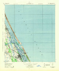
(9)- 1937 Map of Port Orange
 1937 Port Orange1937 Print · USGSThe Volusia County coastline in the late thirties shows a burgeoning network of seaside colonies and rail-connected towns. Genealogists and historians can trace old homesteads and landmarks like the Old Franciscan Mission, Isleboro, and the East Coast Railway.
 - 1943 Map of Port Orange, 1959 Print
 1943 Port Orange1959 Print · USGSThe Florida Atlantic coast during the mid-1940s reveals a landscape of tidal rivers and growing seaside resorts. Researchers can trace the early layout of Port Orange and New Smyrna, locate the Old Franciscan Mission, and see the rail network of the Florida East Coast.
 - 1944 Map of Port Orange
 1944 Port Orange1944 Print · USGSThe Volusia County coastline during the Second World War reveals a landscape of tidal marshes and emerging seaside towns. Genealogists and historians can trace the early footprints of Port Orange, Allandale, and the Old Franciscan Mission along the Halifax River.
 - 1954 Map of Daytona Beach, 1974 Print
 1954 Daytona Beach1974 Print · USGSNortheast Florida is captured in the mid-1950s, showing the transition from river-based commerce to coastal tourism. Researchers can trace the Florida East Coast rail lines and find historic sites like Castillo de San Marcos Nat Mon and Palatka.
 - 1956 Map of New Smyrna Beach, 1960 Print
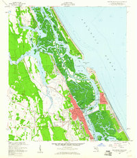 1956 New Smyrna Beach1960 Print · USGSThe Volusia County coastline in the mid-fifties reveals a period of significant growth along the Indian River and Halifax River. Researchers can trace the development of New Smyrna Beach, the legacy of Chisolm High Sch, and the layout of the Florida East Coast Railroad.6 unique versions available
 - 1956 Map of Port Orange, 1964 Print
 1956 Port Orange1964 Print · USGSThe Volusia County coastline comes alive in the mid-fifties, showing the growth of beach communities and the vital Florida East Coast rail line. Genealogists and historians can locate Woodland Cem, Chisholm High Sch, and maritime landmarks near Ponce de Leon Inlet.
 - 1958 Map of Daytona Beach
 1958 Daytona Beach1958 Print · USGSThe Florida coast and St. Johns River valley are captured in the late 1950s, showing a landscape defined by citrus-belt rail towns and Atlantic shorelines. Genealogists can trace family roots through riverside settlements like Palatka and Welaka or coastal hubs like Daytona Beach.2 unique versions available
 - 1964 Map of Daytona Beach
 1964 Daytona Beach1964 Print · USGSCoastal Florida in the mid-1960s shows a fascinating balance between burgeoning beach tourism and the deep interior wilderness of the Ocala National Forest. Researchers can trace the path of the Florida East Coast railway through historic settlements like St. Augustine, Marineland, and Palatka.
 - 1978 Map of New Smyrna Beach, 1980 Print
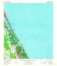
 1978 New Smyrna Beach1980 Print · USGSThe Volusia County coast in the late seventies reveals a landscape defined by the Halifax River and the Atlantic. Researchers can trace the development of Wilbur-by-the-Sea, Allandale, and the U.S. Coast Guard Reservation near Ponce Inlet.2 unique versions available
End of results
Showing maps 1-9 of 9
Top cities near New Smyrna Beach
- Deltona historical maps
- Daytona Beach historical maps
- Ormond Beach historical maps
- Edgewater historical maps
- South Daytona historical maps
- Holly Hill historical maps
See more
Frequently asked questions
- What are the different types of historical maps available for New Smyrna Beach?
- What is the oldest map of New Smyrna Beach?
- Where can I purchase historical maps of New Smyrna Beach for my home or office?
- Where can I download high-res historical maps of New Smyrna Beach?
- Are there historical topographic maps available for New Smyrna Beach?
- Is there historical aerial imagery available for New Smyrna Beach?
- Where are historical maps of New Smyrna Beach sourced from?