1960s Maps of Ormond Beach, Florida
Explore 2 historic maps of Ormond Beach from the 1960s. These maps offer a rare glimpse into what life looked like during the 1960s — showing old roads, neighborhoods, homes, and landmarks that have changed or disappeared over time.
Whether you're researching your family's past, planning a metal detecting trip, or studying how Ormond Beach's landscape evolved across the 1960s, these high-resolution maps are a powerful tool for exploring the history of this region.
- Focus on a specific era: All maps on this page are from the 1960s, giving you a focused view of this time period.
- See what’s changed: Compare century-old streets, trails, and buildings to today's modern landscape using overlays and satellite layers.
- Research with precision: Use these maps for genealogy, historical research, land use analysis, or educational projects.
- View, download, or print: Maps are fully viewable online in high resolution, and can be downloaded or printed for your own records.
Start exploring Ormond Beach's history through authentic maps from the 1960s. This is your window into the past.
Ormond Beach, FL maps
(2)- 1962 Map of Daytona Beach NW, 1964 Print
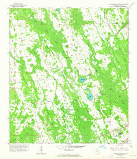 1962 Daytona Beach NW1964 Print · USGSVolusia County's interior wetlands and ridges are captured here during the early sixties, showing a landscape largely defined by water and woods. Genealogists and historians can trace old routes like Jolly Ford Road or locate isolated landmarks such as Harper Ford and Bennett Field.5 unique versions available
 - 1964 Map of Daytona Beach
 1964 Daytona Beach1964 Print · USGSCoastal Florida in the mid-1960s shows a fascinating balance between burgeoning beach tourism and the deep interior wilderness of the Ocala National Forest. Researchers can trace the path of the Florida East Coast railway through historic settlements like St. Augustine, Marineland, and Palatka.
End of results
Showing maps 1-2 of 2
Top cities near Ormond Beach
- Palm Coast historical maps
- Daytona Beach historical maps
- South Daytona historical maps
- Holly Hill historical maps
- Flagler Beach historical maps
- Daytona Beach Shores historical maps
See more
Top neighborhoods of Ormond Beach
Frequently asked questions
- What are the different types of historical maps available for Ormond Beach?
- What is the oldest map of Ormond Beach?
- Where can I purchase historical maps of Ormond Beach for my home or office?
- Where can I download high-res historical maps of Ormond Beach?
- Are there historical topographic maps available for Ormond Beach?
- Is there historical aerial imagery available for Ormond Beach?
- Where are historical maps of Ormond Beach sourced from?