1980s Maps of Milkwater, Fort Defiance Agency
Explore 2 historic maps of Milkwater from the 1980s. These maps offer a rare glimpse into what life looked like during the 1980s — showing old roads, neighborhoods, homes, and landmarks that have changed or disappeared over time.
Whether you're researching your family's past, planning a metal detecting trip, or studying how Milkwater's landscape evolved across the 1980s, these high-resolution maps are a powerful tool for exploring the history of this region.
- Focus on a specific era: All maps on this page are from the 1980s, giving you a focused view of this time period.
- See what’s changed: Compare century-old streets, trails, and buildings to today's modern landscape using overlays and satellite layers.
- Research with precision: Use these maps for genealogy, historical research, land use analysis, or educational projects.
- View, download, or print: Maps are fully viewable online in high resolution, and can be downloaded or printed for your own records.
Start exploring Milkwater's history through authentic maps from the 1980s. This is your window into the past.
Milkwater, Fort Defiance Agency maps
(2)- 1983 Map of Sonsela Buttes
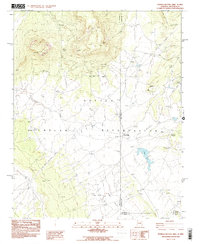 1983 Sonsela Buttes1983 Print · USGSThe Navajo Nation high desert at the start of the 1980s reveals a landscape of isolated springs and remote crossings. Genealogists and historians can locate Milkwater, find a noted site of Graves, and trace the path of Crystal Creek toward Black Lake.2 unique versions available
 - 1984 Map of Canyon De Chelly
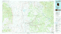 1984 Canyon De Chelly1984 Print · USGSThe Navajo heartland in the mid-eighties shows a landscape of deep canyons and high mesas at a time of rising educational and civic infrastructure. Genealogists and researchers can locate remote trading posts like Upper Greasewood Trading Post and early campus buildings at Navajo Community College.
End of results
Showing maps 1-2 of 2
Top cities near Milkwater
- Shiprock Agency historical maps
- Chinle Agency historical maps
- Fort Defiance Agency historical maps
- Eastern Navajo Agency historical maps
Frequently asked questions
- What are the different types of historical maps available for Milkwater?
- What is the oldest map of Milkwater?
- Where can I purchase historical maps of Milkwater for my home or office?
- Where can I download high-res historical maps of Milkwater?
- Are there historical topographic maps available for Milkwater?
- Is there historical aerial imagery available for Milkwater?
- Where are historical maps of Milkwater sourced from?