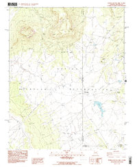
1983 Map of Sonsela Buttes
USGS Topo · Published 1983About this map
Sonsela Buttes and the surrounding high-desert terrain dominate this 1980s landscape on the Navajo Indian Reservation. The geography is defined by a series of springs and seasonal watercourses, including Star Peak Springs, Oak Spring, and Crystal Creek, which carve through the land near Sonsela Saddle. Evidence of human activity is sparse but significant, marked by the small settlement at Milkwater and a lone site labeled Graves near the eastern boundary. The presence of a Borrow Pit and White Bridge suggests localized infrastructure supporting movement through the Black Salt Valley and Red Valley. The map also documents the intersection of state and county lines, where Arizona and New Mexico meet alongside the borders of Apache, San Juan, and McKinley counties, making it a critical reference for understanding the jurisdictional complexity of the Four Corners region during this era.
Find a feature on this map
21 named features on this map. Tap any name to fly to it.
Don’t see what you’re looking for? This feature index may not catch every label — zoom into the map to look around manually.
Map Details
Editions of this 1983 Sonsela Buttes Map
2 editions found
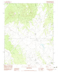
Other maps of this area

1886 · Wingate
USGS Topo · 1:250,000

1886 · Fort Defiance
USGS Topo · 1:250,000

1889 · Chaco
USGS Topo · 1:250,000

1892 · Fort Defiance
USGS Topo · 1:250,000

1892 · Wingate
USGS Topo · 1:250,000

1892 · Chaco
USGS Topo · 1:250,000

1892 · Canyon De Chelly
USGS Topo · 1:250,000

1954 · Shiprock
USGS Topo · 1:250,000

1954 · Gallup
USGS Topo · 1:250,000

1955 · Sonsala Butte 4 SE
USGS Topo · 1:24,000
Featured Places
- Fort Defiance Agency
- Milkwater, Fort Defiance Agency
- San Juan County, NM
- McKinley County, NM
- Apache County, AZ