1970s Maps of Falling Rocks, Georgia
Explore 2 historic maps of Falling Rocks from the 1970s. These maps offer a rare glimpse into what life looked like during the 1970s — showing old roads, neighborhoods, homes, and landmarks that have changed or disappeared over time.
Whether you're researching your family's past, planning a metal detecting trip, or studying how Falling Rocks's landscape evolved across the 1970s, these high-resolution maps are a powerful tool for exploring the history of this region.
- Focus on a specific era: All maps on this page are from the 1970s, giving you a focused view of this time period.
- See what’s changed: Compare century-old streets, trails, and buildings to today's modern landscape using overlays and satellite layers.
- Research with precision: Use these maps for genealogy, historical research, land use analysis, or educational projects.
- View, download, or print: Maps are fully viewable online in high resolution, and can be downloaded or printed for your own records.
Start exploring Falling Rocks's history through authentic maps from the 1970s. This is your window into the past.
Falling Rocks, GA maps
(2)- 1970 Map of Baxley NE, 1974 Print
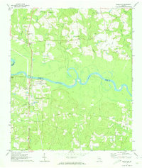 1970 Baxley NE1974 Print · USGSThe Altamaha River corridor comes into focus during the early 1970s as a landscape of rural tradition meeting industrial utility. Genealogists can trace family connections at English Eddy or locate historic sites like Smith Cem and Oak Grove Ch.2 unique versions available
 - 1979 Map of Hazlehurst, 1980 Print
 1979 Hazlehurst1980 Print · USGSSoutheast Georgia in the late seventies is defined by the convergence of major rail lines and river basins in Jeff Davis and Appling counties. Genealogists and local historians can trace the development of Hazlehurst and Baxley alongside features like the Pine Grove Pipeline and the Altamaha River wetlands.
End of results
Showing maps 1-2 of 2
Top cities near Falling Rocks
- Baxley historical maps
- Hazlehurst historical maps
- Reidsville historical maps
- Uvalda historical maps
- Graham historical maps
- Surrency historical maps
See more
Frequently asked questions
- What are the different types of historical maps available for Falling Rocks?
- What is the oldest map of Falling Rocks?
- Where can I purchase historical maps of Falling Rocks for my home or office?
- Where can I download high-res historical maps of Falling Rocks?
- Are there historical topographic maps available for Falling Rocks?
- Is there historical aerial imagery available for Falling Rocks?
- Where are historical maps of Falling Rocks sourced from?