1960s Maps of Winder, Georgia
Explore 5 historic maps of Winder from the 1960s. These maps offer a rare glimpse into what life looked like during the 1960s — showing old roads, neighborhoods, homes, and landmarks that have changed or disappeared over time.
Whether you're researching your family's past, planning a metal detecting trip, or studying how Winder's landscape evolved across the 1960s, these high-resolution maps are a powerful tool for exploring the history of this region.
- Focus on a specific era: All maps on this page are from the 1960s, giving you a focused view of this time period.
- See what’s changed: Compare century-old streets, trails, and buildings to today's modern landscape using overlays and satellite layers.
- Research with precision: Use these maps for genealogy, historical research, land use analysis, or educational projects.
- View, download, or print: Maps are fully viewable online in high resolution, and can be downloaded or printed for your own records.
Start exploring Winder's history through authentic maps from the 1960s. This is your window into the past.
Winder, GA maps
(5)- 1963 Map of Athens
 1963 Athens1963 Print · USGSGeorgia's Piedmont and the Savannah River valley are captured in the early sixties as major reservoirs and military installations reshaped the landscape. Researchers can trace the development of Clark Hill Reservoir, locate the Fort Gordon Military Reservation, and find historic towns like Social Circle and Eatonton.
 - 1964 Map of Bold Springs, 1965 Print
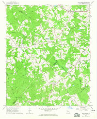 1964 Bold Springs1965 Print · USGSBarrow and Gwinnett counties appear here in the mid-sixties, a landscape of family-run farms and quiet rural crossroads. Researchers can trace historic land use through sites like Kilgore Cem, the Seaboard Air Line rail corridor, and the settlement at Bold Springs.4 unique versions available
 - 1964 Map of Winder North, 1965 Print
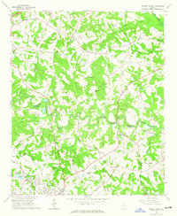 1964 Winder North1965 Print · USGSThe rural borderlands of Jackson and Barrow counties come into focus in the mid-sixties. Researchers can trace family sites like Rose Hill Cem, find the Holsenbeck Sch, and locate old landmarks like the Ebenezer Ch.4 unique versions available
 - 1964 Map of Auburn, 1965 Print
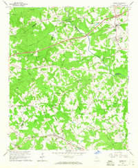 1964 Auburn1965 Print · USGSBarrow and Gwinnett counties come alive in the mid-sixties as the Seaboard Air Line connects the rural hubs of Auburn and Carl. Local researchers can trace historic church sites like Mt Moriah Ch or find the Covered Bridge near Thompsons Mill.3 unique versions available
 - 1964 Map of Winder South, 1965 Print
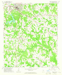 1964 Winder South1965 Print · USGSBarrow and Walton counties come to life in the mid-sixties, showing the transition from the city of Winder to rural crossroads like Bethlehem. Family historians can locate several local landmarks, including the Rose Hill Cem, the Old Fort, and a Covered Bridge on the Apalachee River.3 unique versions available
End of results
Showing maps 1-5 of 5
Top cities near Winder
- Athens historical maps
- Buford historical maps
- Monroe historical maps
- Loganville historical maps
- Jefferson historical maps
- Braselton historical maps
See more
Top neighborhoods of Winder
Frequently asked questions
- What are the different types of historical maps available for Winder?
- What is the oldest map of Winder?
- Where can I purchase historical maps of Winder for my home or office?
- Where can I download high-res historical maps of Winder?
- Are there historical topographic maps available for Winder?
- Is there historical aerial imagery available for Winder?
- Where are historical maps of Winder sourced from?