1970s Maps of Brantley County, Georgia
Explore 13 historic maps of Brantley County from the 1970s. These maps offer a rare glimpse into what life looked like during the 1970s — showing old roads, neighborhoods, homes, and landmarks that have changed or disappeared over time.
Whether you're researching your family's past, planning a metal detecting trip, or studying how Brantley County's landscape evolved across the 1970s, these high-resolution maps are a powerful tool for exploring the history of this region.
- Focus on a specific era: All maps on this page are from the 1970s, giving you a focused view of this time period.
- See what’s changed: Compare century-old streets, trails, and buildings to today's modern landscape using overlays and satellite layers.
- Research with precision: Use these maps for genealogy, historical research, land use analysis, or educational projects.
- View, download, or print: Maps are fully viewable online in high resolution, and can be downloaded or printed for your own records.
Start exploring Brantley County's history through authentic maps from the 1970s. This is your window into the past.
Brantley County, GA maps
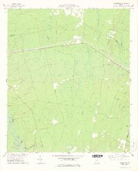
(13)- 1971 Map of Blackshear East, 1974 Print
 1971 Blackshear East1974 Print · USGSPierce County in the early seventies remains a landscape of rural family settlements and small country churches. Genealogists can trace local roots at the Jot 'Em Down Store, Homestead Ch, and the Seaboard Coast Line rail corridor.2 unique versions available
 - 1971 Map of Patterson SE, 1974 Print
 1971 Patterson SE1974 Print · USGSSoutheast of Patterson in the early 1970s, this rural Georgia landscape is defined by the winding Satilla River and its expansive wetlands. Genealogists and local historians can trace family roots through landmarks like Raulerson Cem, Laura Chapel, and the Raulerson Community Center.2 unique versions available
 - 1975 Map of Tarboro, 1987 Print
 1975 Tarboro1987 Print · USGSIn the Georgia lowcountry during the mid-seventies, the community of Tarboro sat at the heart of a wetland landscape. Researchers can trace rural lineages at Bickley Chapel Cem and Harrell Cem, or follow the path of the Old Railroad Grade.
 - 1975 Map of Waynesville, 1987 Print
 1975 Waynesville1987 Print · USGSCoastal Georgia's riverine landscape is captured here in the 1970s, showcasing the winding Satilla River and the settlements of Waynesville and Atkinson. Genealogists can locate family-named sites like Linda Plantation, Ammons Cem, and Wiggins Cem among the swampy lowlands.
 - 1978 Map of Nahunta
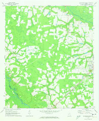
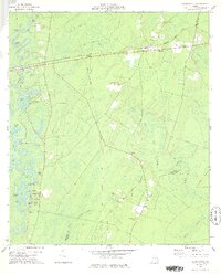
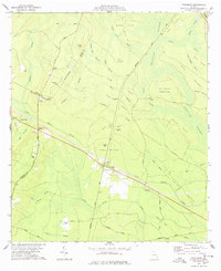
 1978 Nahunta1978 Print · USGSThe rail-and-river landscape of Brantley County is captured here in the late seventies as the timber and swamp country surrounded growing towns. Local researchers can trace family landmarks like Little Buffalo Cem, Raybon Ch, and the rural community of Hickox.2 unique versions available
 - 1978 Map of Waynesville
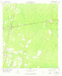
 1978 Waynesville1978 Print · USGSCoastal Georgia in the late 1970s reveals a landscape of river-fed swamps and old rail corridors. Genealogists can trace family names through numerous burial sites like Highsmith Cem or locate historic crossings at Ammons Ferry and Atkinson.
 - 1978 Map of Boons Lake
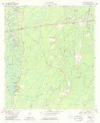
 1978 Boons Lake1978 Print · USGSThe Satilla River's complex oxbows and the expansive Big Bay wetlands defined this rural landscape in the late seventies. Family historians can trace local landmarks like Bethlehem Cem or the settlements at Big Oak and Lime Rock.2 unique versions available
 - 1978 Map of Tarboro
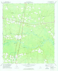
 1978 Tarboro1978 Print · USGSCamden and Brantley Counties are shown in the late 1970s as a landscape of rural churches and extensive wetlands. Genealogists and local historians can trace family-named sites like Harrell Cem and Providence Ch along the Old Railroad Grade.
 - 1978 Map of Browntown
 1978 Browntown1978 Print · USGSThe rural lowlands of Brantley and Wayne County are captured here in the late seventies, showing a landscape defined by the Satilla River. Researchers can trace old family sites at Little Memorial Cem and Mc Cool Cem or follow the path of the Wire Road.2 unique versions available
 - 1978 Map of Hortense
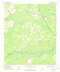
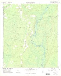
 1978 Hortense1978 Print · USGSIn the late 1970s, the rural junction of Hortense and the winding Satilla River defined this corner of Brantley County. Genealogists and local historians can trace small river landings and country churches from Raybon to Needmore, including Satilla Cem and Lewis Ch.
 - 1978 Map of Brunswick
 1978 Brunswick1978 Print · USGSThe Georgia coast and its barrier islands are captured in the late 1970s, as I-95 and the rail lines shaped the growth of coastal towns. Genealogists and historians can trace family locations across the islands or locate sites near Fort Stewart, Darien, and Ludowici.2 unique versions available
 - 1978 Map of Thalmann
 1978 Thalmann1978 Print · USGSCoastal Georgia's rail junctions and swamp islands are detailed in the late seventies. Genealogists can trace family landmarks across Thalmann, Popwellville, and numerous burial sites like Popwell Cem and Blount Crossing Cem.
 - 1978 Map of Waycross, 1982 Print
 1978 Waycross1982 Print · USGSSoutheast Georgia in the late seventies is a landscape of vast wetlands and busy rail junctions. Genealogists and local historians can trace the Seaboard Coast Line through rural stops like Millwood and Pearson or locate family sites near the Okefenokee Swamp.
End of results
Showing maps 1-13 of 13
Top cities of Brantley County
Frequently asked questions
- What are the different types of historical maps available for Brantley County?
- What is the oldest map of Brantley County?
- Where can I purchase historical maps of Brantley County for my home or office?
- Where can I download high-res historical maps of Brantley County?
- Are there historical topographic maps available for Brantley County?
- Is there historical aerial imagery available for Brantley County?
- Where are historical maps of Brantley County sourced from?