1960s Maps of Waynesboro, Georgia
Explore 4 historic maps of Waynesboro from the 1960s. These maps offer a rare glimpse into what life looked like during the 1960s — showing old roads, neighborhoods, homes, and landmarks that have changed or disappeared over time.
Whether you're researching your family's past, planning a metal detecting trip, or studying how Waynesboro's landscape evolved across the 1960s, these high-resolution maps are a powerful tool for exploring the history of this region.
- Focus on a specific era: All maps on this page are from the 1960s, giving you a focused view of this time period.
- See what’s changed: Compare century-old streets, trails, and buildings to today's modern landscape using overlays and satellite layers.
- Research with precision: Use these maps for genealogy, historical research, land use analysis, or educational projects.
- View, download, or print: Maps are fully viewable online in high resolution, and can be downloaded or printed for your own records.
Start exploring Waynesboro's history through authentic maps from the 1960s. This is your window into the past.
Waynesboro, GA maps
(4)- 1961 Map of Augusta
 1961 Augusta1961 Print · USGSThe South Carolina lowcountry and CSRA appear here in the early sixties, during a period of massive military and industrial growth. Researchers can trace the development of the Savannah River Plant or locate legacy landmarks like Nelson Ferry and Magnolia Cemetery.2 unique versions available
 - 1962 Map of Augusta
 1962 Augusta1962 Print · USGSThe South Carolina and Georgia borderlands are seen here in the early sixties, showing the rise of the Savannah River Plant and the expansion of Fort Jackson. Researchers can trace old rail lines like the Southern Railway and find landmarks such as St. Pauls Church or the Santee Canal.
 - 1963 Map of Athens
 1963 Athens1963 Print · USGSGeorgia's Piedmont and the Savannah River valley are captured in the early sixties as major reservoirs and military installations reshaped the landscape. Researchers can trace the development of Clark Hill Reservoir, locate the Fort Gordon Military Reservation, and find historic towns like Social Circle and Eatonton.
 - 1964 Map of Idlewood, 1965 Print
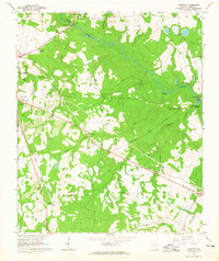 1964 Idlewood1965 Print · USGSBurke County during the mid-1960s reveals a landscape of rural school-and-church centers and winding creek bottoms. Genealogists and local researchers can trace the locations of Watkinville Ch, the settlement of Alexander, and the path of the Central Georgia railroad.2 unique versions available
End of results
Showing maps 1-4 of 4
Top cities near Waynesboro
Frequently asked questions
- What are the different types of historical maps available for Waynesboro?
- What is the oldest map of Waynesboro?
- Where can I purchase historical maps of Waynesboro for my home or office?
- Where can I download high-res historical maps of Waynesboro?
- Are there historical topographic maps available for Waynesboro?
- Is there historical aerial imagery available for Waynesboro?
- Where are historical maps of Waynesboro sourced from?