
Loading...
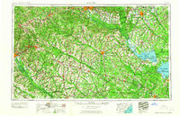
Loading map...1961 Map of Augusta
USGS Topo · Published 1961About this map
Savannah River Plant occupies a massive footprint along the Savannah River south of Augusta, representing the Cold War-era industrialization of the South Carolina lowcountry. This survey shows the region at a point of high connectivity, with major rail lines like the Southern Railway and Atlantic Coast Line Railroad threading through textile and transport hubs like Orangeburg, Aiken, and Columbia.
Find a feature on this map
183 named features on this map. Tap any name to fly to it.
Don’t see what you’re looking for? This feature index may not catch every label — zoom into the map to look around manually.
Map Details
Date Portrayed1961
Date Published1961
PublisherU.S. Geological Survey
Map TypeTopographic
Scale1:250,000
Physical Dimensions34.51 x 22.43 inches
Editions of this 1961 Augusta Map
2 editions found
Historical Maps of Augusta Through Time
7 maps found


Featured Locations
Source Details
SourceU.S. Geological Survey
CopyrightPublic Domain