Old Maps of High Point, Georgia for Academic Research
Study the evolution of High Point with 18 high-resolution historic maps. Whether you're teaching, researching, or modeling changes in land use, these maps provide essential visual documentation of urban, environmental, and geographic change.
- Analyze long-term change: Track patterns in development, transportation, and natural features.
- Ideal for environmental or urban studies: Support academic projects with primary historical map data.
- Use in the classroom or lab: Educators and researchers rely on these maps to bring historical context to life.
These maps are a powerful tool for teaching, research, and visualizing how High Point has changed over the decades.
High Point, GA maps
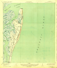
(18)- 1918 Map of Cumberland Island
 1918 Cumberland Island1918 Print · USGSCoastal Georgia at the end of the Great War was a world of secluded island estates and vital maritime waterways. Researchers can trace the early infrastructure of the barrier islands through labels like Greyfield, the Lighthouse (Abandoned), and Plum Orchard Wharf.
 - 1930 Map of Cumberland Island
 1930 Cumberland Island1930 Print · USGSCoastal Camden County during the interwar years is defined by the private estates and tidal marshes of this barrier island. Trace the early estate culture through Greyfield and the numerous landings like Stafford Wharf and the Lighthouse (Abandoned).3 unique versions available
 - 1945 Map of Cumberland Island
 1945 Cumberland Island1945 Print · USGSCamden County's coastal barrier islands are documented here during the mid-forties, showing the maritime infrastructure of the Georgia shore. Genealogists and researchers can trace the locations of historic landings like Plum Orchard Wharf and the settlement at Greyfield.
 - 1948 Map of Jacksonville
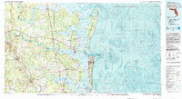
 1948 Jacksonville1948 Print · USGSNortheast Florida and Southeast Georgia's coastal waterways and railroad towns are captured here in the years following the war. Genealogists can trace family connections through river towns like St Marys or identify long-standing military landmarks like Jacksonville NAS.
 - 1957 Map of Jacksonville, 1967 Print
 1957 Jacksonville1967 Print · USGSCoastal Florida and Georgia meet in the late fifties, showcasing a landscape of naval aviation, deep-water terminals, and barrier island communities. Researchers can trace the mid-century footprints of NAS Jacksonville, find small communities like Franklintown, and locate the historic Fort Clinch State Park.3 unique versions available
 - 1958 Map of Cumberland Island North, 1959 Print
 1958 Cumberland Island North1959 Print · USGSCoastal Georgia's barrier islands appear in detail during the late fifties, showcasing the intricate tidal reaches of Camden County. Researchers can trace historic sites like Cumberland Wharf, the Little Cumberland Island Lighthouse, and early Cems near Halfmoon Bluff.
 - 1959 Map of Jacksonville
 1959 Jacksonville1959 Print · USGSNortheast Florida and Southeast Georgia are seen here in the late fifties, dominated by the maritime activity of the St Johns River and the Atlantic coast. Researchers can trace the mid-century layout of Jacksonville and identify sprawling military sites like Camp Blanding Military Reservation and Kings Bay Ammunition Terminal.
 - 1960 Map of Jacksonville
 1960 Jacksonville1960 Print · USGSCoastal Florida and Georgia meet in this mid-century portrait of a region shaped by naval power and the winding St Johns River. Researchers can trace the development of military sites like Cecil Field or locate historic rural landmarks such as Jerusalem Ch and Kings Ferry.
 - 1979 Map of Cumberland Island North, 1980 Print
 1979 Cumberland Island North1980 Print · USGSThe northern reaches of Georgia's barrier islands are captured in the late seventies, showing the meeting of maritime forest and tide. Genealogists and researchers can locate Cumberland Wharf, an ancient Indian Mound, and family-named bluffs like Stockwell Bluff.
 - 1981 Map of Fernandina Beach, 1982 Print
 1981 Fernandina Beach1982 Print · USGSThe coastal borderlands of Georgia and Florida are captured here in the early eighties, from the barrier islands to the rail towns of the interior. Genealogists and historians can trace family-named bluffs and sites like Franklintown, Dungeness Wharf, and St Marys Historical Park.3 unique versions available
 - 1988 Map of Jacksonville
 1988 Jacksonville1988 Print · USGSCoastal Florida and Georgia are captured here during the late eighties, documenting the rapid growth of the First Coast and its vital military installations. Researchers can trace the development of beach communities like Fernandina Beach and Atlantic Beach or locate family landmarks near Mickler Landing and Orange Park.
 - 1993 Map of Cumberland Island North, 1995 Print
 1993 Cumberland Island North1995 Print · USGSThe northern reaches of Georgia's barrier islands appear in the early 1990s as a complex landscape of tidal rivers and maritime history. Researchers can trace landforms and heritage sites like the Little Cumberland Island Lighthouse, the First African Ch, and the Cumberland Cem.
 - 1998 Map of Cumberland Island North, 2001 Print
 1998 Cumberland Island North2001 Print · USGSThe northern reaches of the Georgia barrier islands are captured here in the late nineties, showcasing the intersection of wild coast and isolated settlement. Researchers can trace the heritage of local communities through sites like First African Ch, Cumberland Cem, and the Little Cumberland Island Light (Abandoned).
 - 2011 Map of Cumberland Island North, 2011 Print
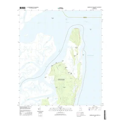
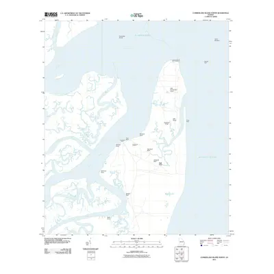 2011 Cumberland Island North2011 Print · USGSCovers High Point, including Glynn County, Camden County, and other nearby areas
 - 2014 Map of Cumberland Island North, 2014 Print
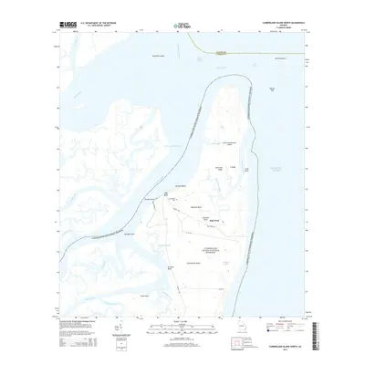 2014 Cumberland Island North2014 Print · USGSCovers High Point, including Glynn County, Camden County, and other nearby areas
 - 2017 Map of Cumberland Island North, 2017 Print
 2017 Cumberland Island North2017 Print · USGSCovers High Point, including Glynn County, Camden County, and other nearby areas
 - 2020 Map of Cumberland Island North, 2020 Print
 2020 Cumberland Island North2020 Print · USGSCovers High Point, including Glynn County, Camden County, and other nearby areas
 - 2024 Map of Cumberland Island North, 2024 Print
 2024 Cumberland Island North2024 Print · USGSCoastal Georgia's barrier island wilderness is preserved here in the modern era, showing the intersection of maritime history and natural preservation. Researchers can locate the Cumberland Cem, trace the Roller Coaster Trl, and explore the marshes of Brickhill Bluff.
End of results
Showing maps 1-18 of 18
Top cities near High Point
- St. Marys historical maps
- Kingsland historical maps
- Brunswick historical maps
- Saint Simons historical maps
- Kings Bay Base historical maps
Frequently asked questions
- What are the different types of historical maps available for High Point?
- What is the oldest map of High Point?
- Where can I purchase historical maps of High Point for my home or office?
- Where can I download high-res historical maps of High Point?
- Are there historical topographic maps available for High Point?
- Is there historical aerial imagery available for High Point?
- Where are historical maps of High Point sourced from?