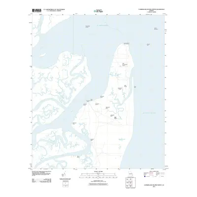
2011 Map of Cumberland Island North
USGS Topo · Published 2011About this map
Little Cumberland Island Lighthouse stands as a sentinel over the tidal marshes and sound waters at the northern end of this barrier island landscape. The terrain is defined by a series of north-south elevations including Sanctuary Ridge and East Ridge, which contrast with the intricate network of tidal waterways such as Brockington Creek and Floyd Creek. The human history of the island is evidenced by the Cumberland Wharf and the Cumberland Cemetery, located near High Bluff. Further south, the map details the transition from high ground at High Point to the wetlands surrounding Whitney Lake. The interface between the Satilla River and St Andrew Sound reveals a complex coastal morphology, with shifting features like Horseshoe Shoals and the North Breakers constantly reshaped by the Atlantic Ocean.
Find a feature on this map
29 named features on this map. Tap any name to fly to it.
Don’t see what you’re looking for? This feature index may not catch every label — zoom into the map to look around manually.
Map Details
Editions of this 2011 Cumberland Island North Map
This is the sole edition of this map. No revisions or reprints were ever made.
Other maps of this area

1918 · Cumberland Island
USGS Topo · 1:62,500

1918 · Bladen
USGS Topo · 1:62,500

1918 · Kingsland
USGS Topo · 1:62,500

1930 · Cumberland Island
USGS Topo · 1:62,500

1939 · Bladen
USGS Topo · 1:62,500

1945 · Brunswick
USGS Topo · 1:62,500

1945 · Cumberland Island
USGS Topo · 1:62,500

1946 · Brunswick
USGS Topo · 1:250,000

1948 · Jacksonville
USGS Topo · 1:250,000

1948 · Brunswick
USGS Topo · 1:250,000