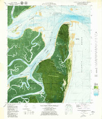
1979 Map of Cumberland Island North
USGS Topo · Published 1980About this map
Cumberland Island National Seashore dominates this 1970s orthophotomap, where aerial imagery and bathymetric data meet to document the shifting sands of the Georgia coast. The map captures the northern tip of Cumberland Island and Little Cumberland Island, separated by the winding Christmas Creek. Historically significant sites like the Indian Mound near High Point and the riverside Cumberland Wharf appear alongside natural landmarks such as Halfmoon Bluff and Sanctuary Ridge.
Find a feature on this map
36 named features on this map. Tap any name to fly to it.
Don’t see what you’re looking for? This feature index may not catch every label — zoom into the map to look around manually.
Map Details
Editions of this 1979 Cumberland Island North Map
This is the sole edition of this map. No revisions or reprints were ever made.
Other maps of this area

1918 · Cumberland Island
USGS Topo · 1:62,500

1918 · Bladen
USGS Topo · 1:62,500

1918 · Kingsland
USGS Topo · 1:62,500

1930 · Cumberland Island
USGS Topo · 1:62,500

1939 · Bladen
USGS Topo · 1:62,500

1945 · Brunswick
USGS Topo · 1:62,500

1945 · Cumberland Island
USGS Topo · 1:62,500

1946 · Brunswick
USGS Topo · 1:250,000

1948 · Jacksonville
USGS Topo · 1:250,000

1948 · Brunswick
USGS Topo · 1:250,000