1990s Maps of Folkston, Georgia
Explore 2 historic maps of Folkston from the 1990s. These maps offer a rare glimpse into what life looked like during the 1990s — showing old roads, neighborhoods, homes, and landmarks that have changed or disappeared over time.
Whether you're researching your family's past, planning a metal detecting trip, or studying how Folkston's landscape evolved across the 1990s, these high-resolution maps are a powerful tool for exploring the history of this region.
- Focus on a specific era: All maps on this page are from the 1990s, giving you a focused view of this time period.
- See what’s changed: Compare century-old streets, trails, and buildings to today's modern landscape using overlays and satellite layers.
- Research with precision: Use these maps for genealogy, historical research, land use analysis, or educational projects.
- View, download, or print: Maps are fully viewable online in high resolution, and can be downloaded or printed for your own records.
Start exploring Folkston's history through authentic maps from the 1990s. This is your window into the past.
Folkston, GA maps
(2)- 1993 Map of Burnt Fort, 1995 Print
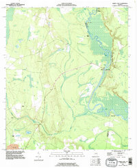 1993 Burnt Fort1995 Print · USGSThe Satilla River serves as the central artery for this Charlton and Camden County borderland in the 1990s. Researchers can trace riverfront heritage at Allens Ferry, Burnt Fort, and O'Berry Cem along the winding wetlands.
 - 1994 Map of Folkston
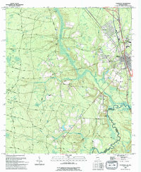 1994 Folkston1994 Print · USGSNear the Georgia-Florida line in the early 1990s, the riverfront settlement at Traders Hill remained a vital landmark. Genealogists and local historians can trace family roots through sites like Traders Hill Cem, Moody Landing Cem, and the rural Bethel Ch.
End of results
Showing maps 1-2 of 2
Top cities near Folkston
Top neighborhoods of Folkston
Frequently asked questions
- What are the different types of historical maps available for Folkston?
- What is the oldest map of Folkston?
- Where can I purchase historical maps of Folkston for my home or office?
- Where can I download high-res historical maps of Folkston?
- Are there historical topographic maps available for Folkston?
- Is there historical aerial imagery available for Folkston?
- Where are historical maps of Folkston sourced from?