1960s Maps of Cherokee County, Georgia
Explore 6 historic maps of Cherokee County from the 1960s. These maps offer a rare glimpse into what life looked like during the 1960s — showing old roads, neighborhoods, homes, and landmarks that have changed or disappeared over time.
Whether you're researching your family's past, planning a metal detecting trip, or studying how Cherokee County's landscape evolved across the 1960s, these high-resolution maps are a powerful tool for exploring the history of this region.
- Focus on a specific era: All maps on this page are from the 1960s, giving you a focused view of this time period.
- See what’s changed: Compare century-old streets, trails, and buildings to today's modern landscape using overlays and satellite layers.
- Research with precision: Use these maps for genealogy, historical research, land use analysis, or educational projects.
- View, download, or print: Maps are fully viewable online in high resolution, and can be downloaded or printed for your own records.
Start exploring Cherokee County's history through authentic maps from the 1960s. This is your window into the past.
Cherokee County, GA maps
(6)- 1961 Map of Rome
 1961 Rome1961 Print · USGSNorthwest Georgia and neighboring Tennessee and Alabama are shown here at a moment of significant mid-century growth. Researchers can trace the rail networks of the Central of Georgia or locate landmarks within Chickamauga and Chattanooga Nat Military Park.
 - 1961 Map of South Canton, 1963 Print
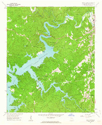 1961 South Canton1963 Print · USGSCherokee County enters a new era of recreation and industry in the early sixties as the reservoir waters reshape the local valleys. Researchers can trace the Louisville and Nashville rail line through Holly Springs or locate rural landmarks like Sutallee and Fields Chapel.4 unique versions available
 - 1961 Map of Allatoona Dam, 1963 Print
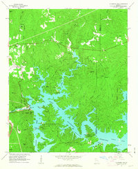 1961 Allatoona Dam1963 Print · USGSBartow and Cherokee counties are shown here just as the reservoir was becoming a regional recreation hub in the early sixties. Genealogists can trace old family burial grounds like Kay Cem and Goodson Cem, or locate rural landmarks like Stamp Creek Ch and Laffingal.4 unique versions available
 - 1961 Map of Canton, 1963 Print
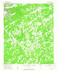 1961 Canton1963 Print · USGSCherokee County in the early sixties centers on the industrial growth of Canton and the winding Etowah River. Local historians can trace family roots through numerous country landmarks like Pugh Cem, Carmichael Crossroads, and Indian Knoll Ch.4 unique versions available
 - 1963 Map of Rome
 1963 Rome1963 Print · USGSThe tri-state corner of Georgia, Alabama, and Tennessee is captured here during a period of massive reservoir expansion and post-war growth. Genealogists and historians can trace the rail corridors of the Southern Ry or locate landmarks like Fort Oglethorpe and Cloudland Canyon State Park.
 - 1968 Map of Allatoona Dam, 1969 Print
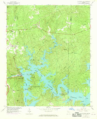 1968 Allatoona Dam1969 Print · USGSBartow County's landscape shows the full impact of the mid-century reservoir projects as recreation and nature preserves take hold in the late 1960s. Trace local family roots at Rowland Spring Cem or explore the site of the Allatoona Dam and its surrounding parklands.
End of results
Showing maps 1-6 of 6
Top cities of Cherokee County
- Woodstock historical maps
- Canton historical maps
- Holly Springs historical maps
- Ball Ground historical maps
- Waleska historical maps
Frequently asked questions
- What are the different types of historical maps available for Cherokee County?
- What is the oldest map of Cherokee County?
- Where can I purchase historical maps of Cherokee County for my home or office?
- Where can I download high-res historical maps of Cherokee County?
- Are there historical topographic maps available for Cherokee County?
- Is there historical aerial imagery available for Cherokee County?
- Where are historical maps of Cherokee County sourced from?