1920s Maps of Cherokee County, Georgia
Explore 2 historic maps of Cherokee County from the 1920s. These maps offer a rare glimpse into what life looked like during the 1920s — showing old roads, neighborhoods, homes, and landmarks that have changed or disappeared over time.
Whether you're researching your family's past, planning a metal detecting trip, or studying how Cherokee County's landscape evolved across the 1920s, these high-resolution maps are a powerful tool for exploring the history of this region.
- Focus on a specific era: All maps on this page are from the 1920s, giving you a focused view of this time period.
- See what’s changed: Compare century-old streets, trails, and buildings to today's modern landscape using overlays and satellite layers.
- Research with precision: Use these maps for genealogy, historical research, land use analysis, or educational projects.
- View, download, or print: Maps are fully viewable online in high resolution, and can be downloaded or printed for your own records.
Start exploring Cherokee County's history through authentic maps from the 1920s. This is your window into the past.
Cherokee County, GA maps
(2)- 1926 Map of Tate, 1968 Print
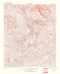 1926 Tate1968 Print · USGSNorthern Georgia's ridge-and-valley corridor is captured here in the mid-twenties, showcasing a landscape of mining and rail commerce. Trace early industrial sites like the Franklin Gold Mine and old crossroads like Ball Ground or Nelson.
 - 1928 Map of Tate
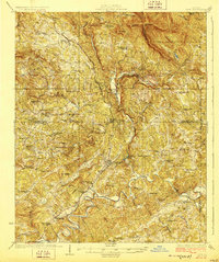 1928 Tate1928 Print · USGSNorth Georgia’s mineral and mountain heritage comes to life in the late 1920s as the rail line connects the marble and gold districts. Researchers can locate family roots at the Franklin Gold Mine, Old Damascus Church, or Burroughs Crossroads.
End of results
Showing maps 1-2 of 2
Top cities of Cherokee County
- Woodstock historical maps
- Canton historical maps
- Holly Springs historical maps
- Ball Ground historical maps
- Waleska historical maps
Frequently asked questions
- What are the different types of historical maps available for Cherokee County?
- What is the oldest map of Cherokee County?
- Where can I purchase historical maps of Cherokee County for my home or office?
- Where can I download high-res historical maps of Cherokee County?
- Are there historical topographic maps available for Cherokee County?
- Is there historical aerial imagery available for Cherokee County?
- Where are historical maps of Cherokee County sourced from?