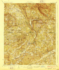
1928 Map of Tate
USGS Topo · Published 1928About this map
Franklin Gold Mine and the Cyanide Prospect highlight the mineral wealth of the North Georgia foothills during the late 1920s. This survey, conducted by S.W. McCallie and topographical engineers, documents a landscape shaped by the State Highway No 5 and Louisville and Nashville Railroad, which snakes through the valley alongside Long Swamp Creek. The density of community life is captured in the numerous family-named landmarks and rural institutions, from Old Damascus Church to Philadelphia Sch.
Find a feature on this map
82 named features on this map. Tap any name to fly to it.
Don’t see what you’re looking for? This feature index may not catch every label — zoom into the map to look around manually.
Map Details
Editions of this 1928 Tate Map
This is the sole edition of this map. No revisions or reprints were ever made.
Other maps of this area

1886 · Dalton
USGS Topo · 1:125,000

1888 · Ellijay
USGS Topo · 1:125,000

1890 · Suwanee
USGS Topo · 1:125,000

1890 · Cartersville
USGS Topo · 1:125,000

1891 · Cartersville
USGS Topo · 1:125,000

1892 · Ellijay
USGS Topo · 1:125,000

1892 · Dalton
USGS Topo · 1:125,000

1894 · Suwanee
USGS Topo · 1:125,000

1896 · Cartersville
USGS Topo · 1:125,000

1897 · Dalton
USGS Topo · 1:125,000