1950s Maps of Dougherty County, Georgia
Explore 13 historic maps of Dougherty County from the 1950s. These maps offer a rare glimpse into what life looked like during the 1950s — showing old roads, neighborhoods, homes, and landmarks that have changed or disappeared over time.
Whether you're researching your family's past, planning a metal detecting trip, or studying how Dougherty County's landscape evolved across the 1950s, these high-resolution maps are a powerful tool for exploring the history of this region.
- Focus on a specific era: All maps on this page are from the 1950s, giving you a focused view of this time period.
- See what’s changed: Compare century-old streets, trails, and buildings to today's modern landscape using overlays and satellite layers.
- Research with precision: Use these maps for genealogy, historical research, land use analysis, or educational projects.
- View, download, or print: Maps are fully viewable online in high resolution, and can be downloaded or printed for your own records.
Start exploring Dougherty County's history through authentic maps from the 1950s. This is your window into the past.
Dougherty County, GA maps
(13)- 1953 Map of Dothan, 1966 Print
 1953 Dothan1966 Print · USGSSoutheast Alabama and Southwest Georgia are captured during a period of massive hydraulic and military expansion in the mid-fifties. Genealogists and historians can trace rural landmarks like Antioch Church and School, the Andrew Jackson Monument, and the early footprint of Fort Rucker Military Reservation.3 unique versions available
 - 1953 Map of Waycross, 1967 Print
 1953 Waycross1967 Print · USGSSouth Georgia's agricultural and rail heartland is captured here in the mid-1950s, showing a vast network of timber and farming towns. Researchers can trace the rail lines connecting Waycross and Tifton or locate landmarks like Jefferson Davis State Park and Lake Blackshear.2 unique versions available
 - 1954 Map of Dothan
 1954 Dothan1954 Print · USGSSoutheast Alabama and Southwest Georgia are seen here in the mid-fifties, during a decade of military expansion and rural transition. Genealogists can trace the location of country schools like Little Zion School or the grounds of Kolomoki Mounds State Park.
 - 1955 Map of Dothan
 1955 Dothan1955 Print · USGSSoutheast Alabama and Southwest Georgia are captured here in the mid-fifties, showing a landscape of river-port history and growing military bases. Researchers can trace rural life via the Andrew Jackson Monument, Bauxite mines, and the Central of Georgia RR.
 - 1956 Map of Albany East, 1957 Print
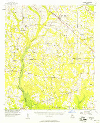
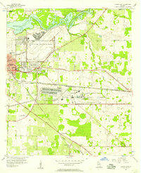 1956 Albany East1957 Print · USGSDougherty County was undergoing a major military expansion in the mid-fifties, seen here through the sprawling grounds of Turner Air Force Base. Researchers can trace old family-named churches like Mercer Grove Ch and the crossroads at Pecan City.4 unique versions available
 - 1956 Map of Albany West, 1957 Print
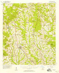
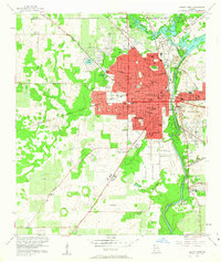 1956 Albany West1957 Print · USGSMid-century Dougherty County centers on the thriving rail and river hub of Albany as it expanded westward toward the state nursery and municipal airport. Genealogists and local historians can trace the footprints of Crown Hill Cemetery, Radium Springs, and the Albany Speedway (Abandoned).4 unique versions available
 - 1956 Map of Baconton, 1957 Print
 1956 Baconton1957 Print · USGSMitchell and Dougherty counties in the mid-fifties are defined by the winding Flint River and a dense network of rural rail lines. Researchers can trace genealogical roots through dozens of local landmarks like Noahs Ark Ch, Hard Up Cem, and Sale City.2 unique versions available
 - 1956 Map of Newton, 1958 Print
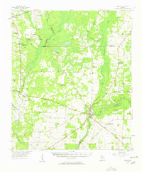 1956 Newton1958 Print · USGSBaker County in the mid-fifties is captured here as a landscape of rural schoolhouses and riverfront commerce. Researchers can locate specific family sites and community centers like New Salem Sch, Travelers Rest, and Mt Airy.
 - 1956 Map of Sylvester, 1958 Print
 1956 Sylvester1958 Print · USGSWorth County at the height of the mid-fifties is centered on the busy rail-and-road corridor between Sylvester and Poulan. Genealogists and historians can locate dozens of rural landmarks, from the County Prison Farm to community hubs like Porters Corner Sch and Morning Star Ch.2 unique versions available
 - 1956 Map of Sasser, 1958 Print
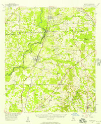
 1956 Sasser1958 Print · USGSTerrell and Dougherty counties are mapped here during the mid-fifties, revealing a rural Georgia landscape of swampy creeks and rail-side hamlets. Researchers can locate specific family landmarks like Clarks Mill, the Andrew Jackson Historical Monument, and Mt Mary Cem & Ch.2 unique versions available
 - 1956 Map of Doerun, 1958 Print
 1956 Doerun1958 Print · USGSIn the mid-1950s, the rural borderlands of Colquitt, Worth, and Mitchell counties were connected by a dense rail-and-river network. Genealogists and local historians can trace family landmarks and vanished schools from Doerun to Bridgeboro, including Parkerville Sch and the Evergreen Cem.
 - 1956 Map of Albany, 1958 Print
 1956 Albany1958 Print · USGSMid-century Albany and the Flint River valley are captured here just as the Cold War military footprint was expanding. Genealogists can trace family landmarks like Radium Springs, the Turner Air Force Base, and Pecan City.2 unique versions available
 - 1958 Map of Waycross
 1958 Waycross1958 Print · USGSSoutheast Georgia in the late fifties remains a landscape of deep river basins and vital rail junctions. Genealogists and historians can trace family-named landmarks and rural hubs like Union Church, South Georgia College, and the sprawling Okefenokee Swamp.2 unique versions available
End of results
Showing maps 1-13 of 13
Top cities of Dougherty County
Frequently asked questions
- What are the different types of historical maps available for Dougherty County?
- What is the oldest map of Dougherty County?
- Where can I purchase historical maps of Dougherty County for my home or office?
- Where can I download high-res historical maps of Dougherty County?
- Are there historical topographic maps available for Dougherty County?
- Is there historical aerial imagery available for Dougherty County?
- Where are historical maps of Dougherty County sourced from?