1970s Maps of Dougherty County, Georgia
Explore 11 historic maps of Dougherty County from the 1970s. These maps offer a rare glimpse into what life looked like during the 1970s — showing old roads, neighborhoods, homes, and landmarks that have changed or disappeared over time.
Whether you're researching your family's past, planning a metal detecting trip, or studying how Dougherty County's landscape evolved across the 1970s, these high-resolution maps are a powerful tool for exploring the history of this region.
- Focus on a specific era: All maps on this page are from the 1970s, giving you a focused view of this time period.
- See what’s changed: Compare century-old streets, trails, and buildings to today's modern landscape using overlays and satellite layers.
- Research with precision: Use these maps for genealogy, historical research, land use analysis, or educational projects.
- View, download, or print: Maps are fully viewable online in high resolution, and can be downloaded or printed for your own records.
Start exploring Dougherty County's history through authentic maps from the 1970s. This is your window into the past.
Dougherty County, GA maps
(11)- 1973 Map of Pretoria, 1974 Print
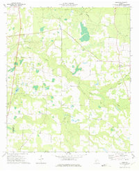
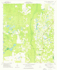
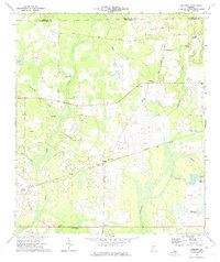 1973 Pretoria1974 Print · USGSDougherty County in the early seventies shows a landscape of rail-connected settlements and winding creek bottoms. Genealogists and local historians can trace family locations near Pretoria, Lockett Crossing, and rural landmarks like Mossy Grove Ch.2 unique versions available
 - 1973 Map of Acree, 1975 Print
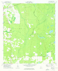
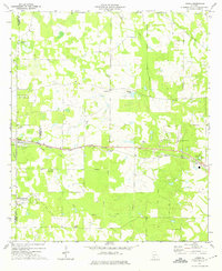 1973 Acree1975 Print · USGSCoastal Georgia's rural landscape is captured here in the early seventies as the railroad still defined the local economy. Genealogists and historians can trace family roots through numerous country churches like Beulah Ch and Salem Ch, or locate the old Seaboard Coast Line rail stops.2 unique versions available
 - 1973 Map of Holt, 1975 Print
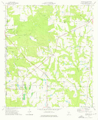
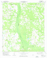 1973 Holt1975 Print · USGSThe rural borders of Calhoun and Dougherty Counties come alive in this early 1970s survey. Researchers can trace the Central of Georgia rail line and locate long-standing community landmarks like Gillionville, Salem Ch, and Holt.
 - 1973 Map of Albany NE, 1975 Print
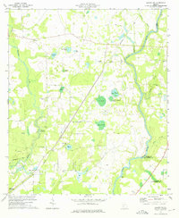 1973 Albany NE1975 Print · USGSLee and Worth counties are captured in the early 1970s, showing a landscape defined by the winding Flint River and a dense network of namesake ponds. You can trace family history at Thundering Springs Cem and Old Mt Horeb Cem, or locate landmarks like Old Piney Grove Ch.2 unique versions available
 - 1973 Map of Doles, 1975 Print
 1973 Doles1975 Print · USGSWorth County was a landscape of quiet rural parishes and winding waterways in the early 1970s. Genealogists and local researchers can locate several community centers and landmarks, including Doles, Camp Osborn, and rural churches like St Johns Ch and New Provisor Ch.
 - 1974 Map of Putney, 1976 Print
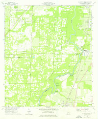
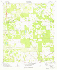 1974 Putney1976 Print · USGSDougherty and Mitchell counties appear here in the mid-seventies, showing a landscape of traditional crossroads and rail-side growth. Researchers can trace rural lineages through numerous country churches like Mt Calvary Ch and New Salem Ch, or follow the historic Stagecoach Road.2 unique versions available
 - 1974 Map of Bermuda, 1976 Print
 1974 Bermuda1976 Print · USGSSouthwest Georgia's riverine borderlands are captured here in the mid-1970s, showcasing the rural landscapes where Baker, Calhoun, and Dougherty counties meet. Researchers can locate family landmarks like Mt Pleasant Ch or trace the Central of Georgia rail line past Bermuda.
 - 1974 Map of Bridgeboro, 1976 Print
 1974 Bridgeboro1976 Print · USGSWorth County agricultural and rail life is well-documented in this mid-seventies survey of the Bridgeboro area. Researchers can trace family history through sites like Rocky Mount Cem or locate the junction of the Georgia Northern railroad at Parkerville.2 unique versions available
 - 1974 Map of Red Store Crossroads, 1976 Print
 1974 Red Store Crossroads1976 Print · USGSSouthwest Georgia in the mid-1970s was a landscape of cypress swamps and quiet rural hubs like Red Store Crossroads. Genealogists and historians can trace family locations along Tarva Road or near landmarks like Chapel Hill Ch and Whitehill Cem.
 - 1974 Map of Baconton North, 1976 Print
 1974 Baconton North1976 Print · USGSThe Flint River basin in the mid-1970s reveals a landscape of river-bend settlements and deep-rooted rural communities. Family historians can trace landmarks like Hard Up Cem, Pleasant Grove Ch, and the rail corridor serving Putney and Baconton.2 unique versions available
 - 1979 Map of Moultrie, 1980 Print
 1979 Moultrie1980 Print · USGSSouth Georgia’s agricultural heartland is documented here in the late 1970s, showcasing the intricate rail and river networks of Colquitt and Tift Counties. Researchers can trace historic settlements along the Georgia Northern railroad or locate landmarks like Spence Air Force Auxiliary Field and Banks Lake.2 unique versions available
End of results
Showing maps 1-11 of 11
Top cities of Dougherty County
Frequently asked questions
- What are the different types of historical maps available for Dougherty County?
- What is the oldest map of Dougherty County?
- Where can I purchase historical maps of Dougherty County for my home or office?
- Where can I download high-res historical maps of Dougherty County?
- Are there historical topographic maps available for Dougherty County?
- Is there historical aerial imagery available for Dougherty County?
- Where are historical maps of Dougherty County sourced from?