1950s Maps of Effingham County, Georgia
Explore 8 historic maps of Effingham County from the 1950s. These maps offer a rare glimpse into what life looked like during the 1950s — showing old roads, neighborhoods, homes, and landmarks that have changed or disappeared over time.
Whether you're researching your family's past, planning a metal detecting trip, or studying how Effingham County's landscape evolved across the 1950s, these high-resolution maps are a powerful tool for exploring the history of this region.
- Focus on a specific era: All maps on this page are from the 1950s, giving you a focused view of this time period.
- See what’s changed: Compare century-old streets, trails, and buildings to today's modern landscape using overlays and satellite layers.
- Research with precision: Use these maps for genealogy, historical research, land use analysis, or educational projects.
- View, download, or print: Maps are fully viewable online in high resolution, and can be downloaded or printed for your own records.
Start exploring Effingham County's history through authentic maps from the 1950s. This is your window into the past.
Effingham County, GA maps
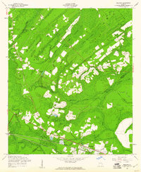
(8)- 1950 Map of Meldrim
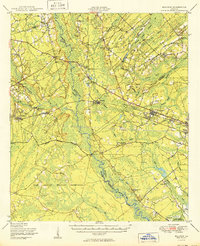 1950 Meldrim1950 Print · USGSCoastal Georgia in the late forties is defined by the rail lines and river swamps that connect inland towns like Meldrim and Blitchton. Genealogists can trace family landmarks and rural life at the Scaffletown School, Bethesda Ch, and Blitch Cem.2 unique versions available
 - 1953 Map of Hardeeville
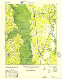 1953 Hardeeville1953 Print · USGSThe riverfront and rail corridors of the South Carolina lowcountry are frozen in time just after the war. Researchers can trace the timber industry through sites like Ebenezer Log, locate the old Okatie Club, or find the Indian Mound near Purrysburg.
 - 1955 Map of Port Wentworth, 1957 Print
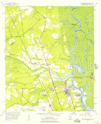 1955 Port Wentworth1957 Print · USGSCoastal Georgia at the mid-century reveals a complex landscape of river commerce and expanding rail networks north of Savannah. Genealogists and historians can trace family-named sites like Meinhard, Cherokee Hill Cem, and the old Goshen Ch as they appeared before modern development.2 unique versions available
 - 1957 Map of Savannah, 1967 Print
 1957 Savannah1967 Print · USGSThe Lowcountry and Georgia coastal plain are shown here in the late fifties, prior to modern expansion. Researchers can trace the rail-and-river economy through the Central of Georgia lines and the Ogeechee River wetlands.4 unique versions available
 - 1958 Map of Meldrim SE, 1961 Print
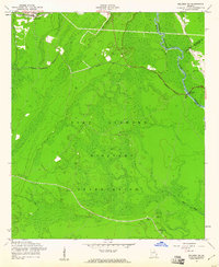
 1958 Meldrim SE1961 Print · USGSThe Ogeechee River corridor is shown in the late fifties as rail lines like the Central of Georgia connect local towns. Researchers can trace family sites like Hopeton Plantation, Ennis Cem, and Spring Hill Ch.4 unique versions available
 - 1958 Map of Meldrim, 1961 Print
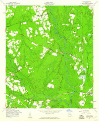
 1958 Meldrim1961 Print · USGSThe Effingham and Chatham county line in the late fifties was a land of timber and tracks centered on the railroad junction at Meldrim. Researchers can trace old rural communities through sites like Marlow Sch, Union Ch, and the crossing of the Central of Georgia railroad.4 unique versions available
 - 1958 Map of Meldrim SW, 1961 Print
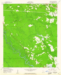
 1958 Meldrim SW1961 Print · USGSCoastal Georgia's transition to a military landscape is documented here during the late fifties, showing the area around the Ogeechee River. Genealogists and historians can trace the former community of Clyde (Site), finding family-named landmarks like Clyde Cem and Wise Cem.3 unique versions available
 - 1958 Map of Eden, 1961 Print
 1958 Eden1961 Print · USGSThe Georgia coastal plain at the end of the 1950s reveals a landscape of river swamps and rail-side settlements. Genealogists and researchers can locate numerous rural landmarks such as Black Creek Sch, Sand Hill Cem, and the Silica Quarry near Eden.2 unique versions available
End of results
Showing maps 1-8 of 8
Top cities of Effingham County
Frequently asked questions
- What are the different types of historical maps available for Effingham County?
- What is the oldest map of Effingham County?
- Where can I purchase historical maps of Effingham County for my home or office?
- Where can I download high-res historical maps of Effingham County?
- Are there historical topographic maps available for Effingham County?
- Is there historical aerial imagery available for Effingham County?
- Where are historical maps of Effingham County sourced from?