1940s Maps of Elrod Mill, Georgia
Explore 2 historic maps of Elrod Mill from the 1940s. These maps offer a rare glimpse into what life looked like during the 1940s — showing old roads, neighborhoods, homes, and landmarks that have changed or disappeared over time.
Whether you're researching your family's past, planning a metal detecting trip, or studying how Elrod Mill's landscape evolved across the 1940s, these high-resolution maps are a powerful tool for exploring the history of this region.
- Focus on a specific era: All maps on this page are from the 1940s, giving you a focused view of this time period.
- See what’s changed: Compare century-old streets, trails, and buildings to today's modern landscape using overlays and satellite layers.
- Research with precision: Use these maps for genealogy, historical research, land use analysis, or educational projects.
- View, download, or print: Maps are fully viewable online in high resolution, and can be downloaded or printed for your own records.
Start exploring Elrod Mill's history through authentic maps from the 1940s. This is your window into the past.
Elrod Mill, GA maps
(2)- 1946 Map of Blue Ridge, 1960 Print
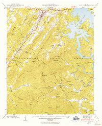 1946 Blue Ridge1960 Print · USGSFannin and Gilmer Counties are captured here shortly after the war, showing the mountain communities of the Chattahoochee National Forest before modern expansion. Researchers can trace the roots of local families through the many rural landmarks like Cherrylog Church, Ballew Mill, and Snake Nation School.3 unique versions available
 - 1947 Map of Lake Toccoa
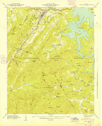 1947 Lake Toccoa1947 Print · USGSFannin and Gilmer counties are captured here shortly after the war, showing the mountain communities and logging routes of North Georgia. Researchers can trace family sites like Antioch Cemetery, find old industrial locations including Greens Mill, or locate the historic Shallowford Bridge.2 unique versions available
End of results
Showing maps 1-2 of 2
Top cities near Elrod Mill
- Ellijay historical maps
- McCaysville historical maps
- Blue Ridge historical maps
- East Ellijay historical maps
- Copperhill historical maps
- Ducktown historical maps
See more
Frequently asked questions
- What are the different types of historical maps available for Elrod Mill?
- What is the oldest map of Elrod Mill?
- Where can I purchase historical maps of Elrod Mill for my home or office?
- Where can I download high-res historical maps of Elrod Mill?
- Are there historical topographic maps available for Elrod Mill?
- Is there historical aerial imagery available for Elrod Mill?
- Where are historical maps of Elrod Mill sourced from?