1970s Maps of Ellijay, Georgia
Explore 2 historic maps of Ellijay from the 1970s. These maps offer a rare glimpse into what life looked like during the 1970s — showing old roads, neighborhoods, homes, and landmarks that have changed or disappeared over time.
Whether you're researching your family's past, planning a metal detecting trip, or studying how Ellijay's landscape evolved across the 1970s, these high-resolution maps are a powerful tool for exploring the history of this region.
- Focus on a specific era: All maps on this page are from the 1970s, giving you a focused view of this time period.
- See what’s changed: Compare century-old streets, trails, and buildings to today's modern landscape using overlays and satellite layers.
- Research with precision: Use these maps for genealogy, historical research, land use analysis, or educational projects.
- View, download, or print: Maps are fully viewable online in high resolution, and can be downloaded or printed for your own records.
Start exploring Ellijay's history through authentic maps from the 1970s. This is your window into the past.
Ellijay, GA maps
(2)- 1971 Map of Webb, 1973 Print
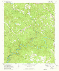 1971 Webb1973 Print · USGSGilmer County is seen here in the early 1970s as the rising waters of Carters Lake began to reshape the Coosawattee River valley. Genealogists can locate family landmarks like New Hope Ch, Cross Roads Ch, and the small settlement of Elders.2 unique versions available
 - 1971 Map of Ellijay, 1973 Print
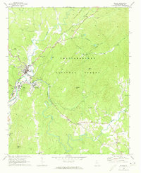 1971 Ellijay1973 Print · USGSNorth Georgia’s mountain valleys are captured in the early seventies at the meeting of three rivers. Genealogists and historians can trace the Louisville and Nashville rail corridor through Ellijay to rural sites like Mt Zion Ch and the Flint Hill Cem Ch.2 unique versions available
End of results
Showing maps 1-2 of 2
Top cities near Ellijay
- Jasper historical maps
- Blue Ridge historical maps
- East Ellijay historical maps
- Talking Rock historical maps
- Ranger historical maps
Frequently asked questions
- What are the different types of historical maps available for Ellijay?
- What is the oldest map of Ellijay?
- Where can I purchase historical maps of Ellijay for my home or office?
- Where can I download high-res historical maps of Ellijay?
- Are there historical topographic maps available for Ellijay?
- Is there historical aerial imagery available for Ellijay?
- Where are historical maps of Ellijay sourced from?