1960s Maps of Jones County, Georgia
Explore 6 historic maps of Jones County from the 1960s. These maps offer a rare glimpse into what life looked like during the 1960s — showing old roads, neighborhoods, homes, and landmarks that have changed or disappeared over time.
Whether you're researching your family's past, planning a metal detecting trip, or studying how Jones County's landscape evolved across the 1960s, these high-resolution maps are a powerful tool for exploring the history of this region.
- Focus on a specific era: All maps on this page are from the 1960s, giving you a focused view of this time period.
- See what’s changed: Compare century-old streets, trails, and buildings to today's modern landscape using overlays and satellite layers.
- Research with precision: Use these maps for genealogy, historical research, land use analysis, or educational projects.
- View, download, or print: Maps are fully viewable online in high resolution, and can be downloaded or printed for your own records.
Start exploring Jones County's history through authentic maps from the 1960s. This is your window into the past.
Jones County, GA maps
(6)- 1963 Map of Athens
 1963 Athens1963 Print · USGSGeorgia's Piedmont and the Savannah River valley are captured in the early sixties as major reservoirs and military installations reshaped the landscape. Researchers can trace the development of Clark Hill Reservoir, locate the Fort Gordon Military Reservation, and find historic towns like Social Circle and Eatonton.
 - 1964 Map of Macon
 1964 Macon1964 Print · USGSCentral Georgia in the mid-sixties is defined by its major river valleys and a booming military presence. Genealogists and historians can trace the growth of Warner Robins near Robins AFB or locate smaller rural junctions like Allentown and Jeffersonville along the historic Southern railroad lines.2 unique versions available
 - 1964 Map of Gray, 1965 Print
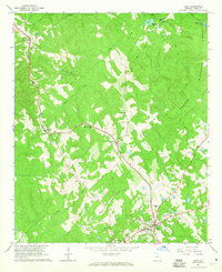 1964 Gray1965 Print · USGSJones County's landscape in the mid-1960s is defined by the intersection of the Oconee National Forest and the Central of Georgia rail line. Researchers can locate community anchors like the Bradley-Wayside Sch and Stewart Chapel, alongside the developing township of Gray.2 unique versions available
 - 1964 Map of Dames Ferry, 1965 Print
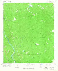 1964 Dames Ferry1965 Print · USGSThe Ocmulgee River corridor in the mid-1960s shows a landscape transitioning between working riverfront and protected federal forest. Researchers can trace rural church sites and family cemeteries like Zion Hill Ch and Little Rock Cem near the river crossing at Dames Ferry.2 unique versions available
 - 1964 Map of Stanfordville, 1965 Print
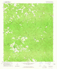 1964 Stanfordville1965 Print · USGSJasper and Putnam counties are seen here in the mid-1960s, a time when the forestry and recreation of the Piedmont defined local life. Genealogists and historians can trace community roots through Mt Carmel Ch, Goolsby, and the Union Hill Ch Cem.3 unique versions available
 - 1964 Map of Hillsboro, 1965 Print
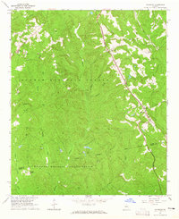 1964 Hillsboro1965 Print · USGSJasper County was a landscape of rail-connected hamlets and federal timberlands during the mid-sixties. Genealogists and historians can trace the Central of Georgia line through Adgateville and Hillsboro, or locate family landmarks like Rock Zion Ch.3 unique versions available
End of results
Showing maps 1-6 of 6
Top cities of Jones County
Frequently asked questions
- What are the different types of historical maps available for Jones County?
- What is the oldest map of Jones County?
- Where can I purchase historical maps of Jones County for my home or office?
- Where can I download high-res historical maps of Jones County?
- Are there historical topographic maps available for Jones County?
- Is there historical aerial imagery available for Jones County?
- Where are historical maps of Jones County sourced from?