1970s Maps of Jones County, Georgia
Explore 10 historic maps of Jones County from the 1970s. These maps offer a rare glimpse into what life looked like during the 1970s — showing old roads, neighborhoods, homes, and landmarks that have changed or disappeared over time.
Whether you're researching your family's past, planning a metal detecting trip, or studying how Jones County's landscape evolved across the 1970s, these high-resolution maps are a powerful tool for exploring the history of this region.
- Focus on a specific era: All maps on this page are from the 1970s, giving you a focused view of this time period.
- See what’s changed: Compare century-old streets, trails, and buildings to today's modern landscape using overlays and satellite layers.
- Research with precision: Use these maps for genealogy, historical research, land use analysis, or educational projects.
- View, download, or print: Maps are fully viewable online in high resolution, and can be downloaded or printed for your own records.
Start exploring Jones County's history through authentic maps from the 1970s. This is your window into the past.
Jones County, GA maps
(10)- 1973 Map of East Juliette, 1975 Print
 1973 East Juliette1975 Print · USGSThe riverfront communities of Juliette and East Juliette are shown during the 1970s at the junction of the Ocmulgee and Towaliga rivers. Researchers can trace rural life through numerous landmarks like Browns Chapel, Bethesda Ch, and Holly Grove Cem.
 - 1973 Map of Berner, 1975 Print
 1973 Berner1975 Print · USGSCentral Georgia's river-cut timberlands are captured here in the early seventies, showing the rural communities of Jasper and Butts counties. Genealogists and historians can trace the Southern railroad corridor through Berner and locate country congregations like Ward Ch.2 unique versions available
 - 1973 Map of Gordon, 1977 Print
 1973 Gordon1977 Print · USGSWilkinson County industries and rural rail stops are in focus during the early seventies. Genealogists and historians can trace family locations near Stevens Pottery, Lake Tchutolako, and several country churches like Emmanuel Ch or Smith Chapel.2 unique versions available
 - 1973 Map of Macon NE, 1977 Print
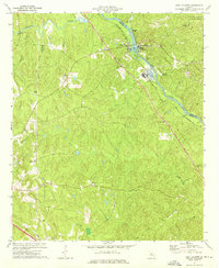
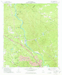
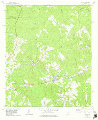
 1973 Macon NE1977 Print · USGSJones County and the northern outskirts of Macon are shown here in the mid-seventies as suburban growth began to meet established rural crossroads. Researchers can trace family history through the Mattie Wells Sch and numerous burial sites like Harris Cem and Stiles Cem.2 unique versions available
 - 1973 Map of Macon NW, 1977 Print
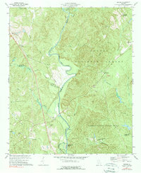
 1973 Macon NW1977 Print · USGSThe Ocmulgee River corridor north of Macon shows a landscape of river-bend settlements and expanding suburbs in the early seventies. Genealogists and local historians can trace family landmarks like Sardis Cem, the rural outpost at Popes Ferry, and Wesleyan College.2 unique versions available
 - 1973 Map of James, 1977 Print
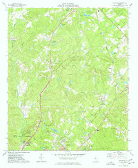
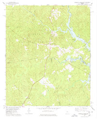
 1973 James1977 Print · USGSJones and Wilkinson counties come into focus in the 1970s as rural communities thrive along the Central of Georgia railroad. Researchers can trace ancestral roots through small settlements like Lewiston, find local landmarks such as Mountain Springs, and locate several rural churches including New Salem Ch.2 unique versions available
 - 1973 Map of Dry Branch, 1977 Print
 1973 Dry Branch1977 Print · USGSTwiggs County's kaolin mining landscape and rural crossroads are captured here in the early 1970s. Trace local family roots at Nelson Cem or explore industrial history through the sprawling Clay Pits and the historic site of Myricks Mill.2 unique versions available
 - 1978 Map of Resseaus Crossroads
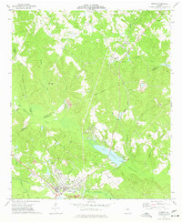
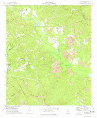
 1978 Resseaus Crossroads1978 Print · USGSPutnam and Jones counties appear here in the late seventies as the recreation-driven economy of the reservoir began to shape the landscape. Researchers can trace old family sites near Resseaus Crossroads, Pierce Chapel Ch, and the shores of Lake Sinclair.3 unique versions available
 - 1978 Map of Haddock
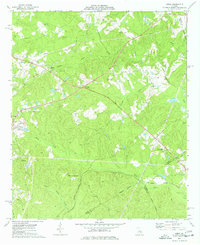
 1978 Haddock1978 Print · USGSJones County's rural communities and small-town crossroads are captured here in the late seventies as the region balanced forestry and small-scale development. Genealogists and historians can locate family burial sites and country churches like Fortville Cem, Mt Zion Ch Cem, and Blountsville.
 - 1978 Map of Macon, 1980 Print
 1978 Macon1980 Print · USGSCentral Georgia during the late seventies reveals a landscape shaped by military expansion and clay mining. Genealogists and local historians can trace the development of Warner Robins, the grounds of Wesleyan College, and the rural surroundings of Griswoldville.2 unique versions available
End of results
Showing maps 1-10 of 10
Top cities of Jones County
Frequently asked questions
- What are the different types of historical maps available for Jones County?
- What is the oldest map of Jones County?
- Where can I purchase historical maps of Jones County for my home or office?
- Where can I download high-res historical maps of Jones County?
- Are there historical topographic maps available for Jones County?
- Is there historical aerial imagery available for Jones County?
- Where are historical maps of Jones County sourced from?