1950s Maps of Riceboro, Georgia
Explore 6 historic maps of Riceboro from the 1950s. These maps offer a rare glimpse into what life looked like during the 1950s — showing old roads, neighborhoods, homes, and landmarks that have changed or disappeared over time.
Whether you're researching your family's past, planning a metal detecting trip, or studying how Riceboro's landscape evolved across the 1950s, these high-resolution maps are a powerful tool for exploring the history of this region.
- Focus on a specific era: All maps on this page are from the 1950s, giving you a focused view of this time period.
- See what’s changed: Compare century-old streets, trails, and buildings to today's modern landscape using overlays and satellite layers.
- Research with precision: Use these maps for genealogy, historical research, land use analysis, or educational projects.
- View, download, or print: Maps are fully viewable online in high resolution, and can be downloaded or printed for your own records.
Start exploring Riceboro's history through authentic maps from the 1950s. This is your window into the past.
Riceboro, GA maps
(6)- 1950 Map of Hinesville
 1950 Hinesville1950 Print · USGSLiberty County was undergoing a major transformation at mid-century as the military footprint grew around Hinesville. Genealogists and historians can trace the foundations of this change through landmarks like Terrells Millpond, Providence School, and the Cypress Slash Cem.2 unique versions available
 - 1950 Map of Limerick
 1950 Limerick1950 Print · USGSThe Georgia lowcountry at the mid-century mark shows a transition from coastal plantations to military and industrial expansion. Genealogists and historians can trace family roots through numerous sites like Dorchester Academy, Sunbury, and Scratchy Hall Cem.2 unique versions available
 - 1955 Map of Riceboro, 1959 Print
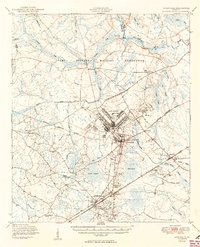
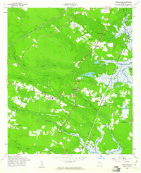
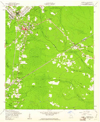
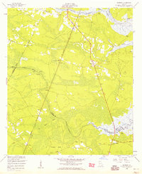 1955 Riceboro1959 Print · USGSCoastal Georgia in the mid-fifties is defined here by the intersection of the Seaboard Air Line Railroad and the vast marshlands of Liberty and McIntosh Counties. Researchers can locate community centers like Riceboro, the First African Ch, and long-standing family landmarks such as Pando Cem.2 unique versions available
 - 1956 Map of Brunswick, 1968 Print
 1956 Brunswick1968 Print · USGSThe Georgia coast in the mid-twentieth century is a wild expanse of barrier islands and massive river deltas. You can trace the development of the maritime economy and military presence at Brunswick, or locate historic sites like Fort Frederica National Monument and Harris Neck National Wildlife Refuge.2 unique versions available
 - 1958 Map of Dorchester, 1961 Print
 1958 Dorchester1961 Print · USGSCoastal Georgia in the late fifties was a landscape of dense swamps and rail-side settlements. Genealogists can trace family roots through numerous local landmarks like Liberty County High Sch, Midway, and Beech Hill Ch.3 unique versions available
 - 1958 Map of Hinesville, 1961 Print
 1958 Hinesville1961 Print · USGSGeorgia's coastal plain south of Fort Stewart comes into focus in the late fifties, showing the area's transition between military expansion and deep-rooted rural settlements. Genealogists and historians can trace local family landmarks like Cypress Slash Cem, Walthourville, and Taylor Creek Ch.3 unique versions available
End of results
Showing maps 1-6 of 6
Top cities near Riceboro
- Savannah historical maps
- Hinesville historical maps
- Richmond Hill historical maps
- Fort Stewart historical maps
- Walthourville historical maps
- Midway historical maps
See more
Top neighborhoods of Riceboro
Frequently asked questions
- What are the different types of historical maps available for Riceboro?
- What is the oldest map of Riceboro?
- Where can I purchase historical maps of Riceboro for my home or office?
- Where can I download high-res historical maps of Riceboro?
- Are there historical topographic maps available for Riceboro?
- Is there historical aerial imagery available for Riceboro?
- Where are historical maps of Riceboro sourced from?