1980s Maps of Long County, Georgia
Explore 3 historic maps of Long County from the 1980s. These maps offer a rare glimpse into what life looked like during the 1980s — showing old roads, neighborhoods, homes, and landmarks that have changed or disappeared over time.
Whether you're researching your family's past, planning a metal detecting trip, or studying how Long County's landscape evolved across the 1980s, these high-resolution maps are a powerful tool for exploring the history of this region.
- Focus on a specific era: All maps on this page are from the 1980s, giving you a focused view of this time period.
- See what’s changed: Compare century-old streets, trails, and buildings to today's modern landscape using overlays and satellite layers.
- Research with precision: Use these maps for genealogy, historical research, land use analysis, or educational projects.
- View, download, or print: Maps are fully viewable online in high resolution, and can be downloaded or printed for your own records.
Start exploring Long County's history through authentic maps from the 1980s. This is your window into the past.
Long County, GA maps
(3)- 1980 Map of Riceboro
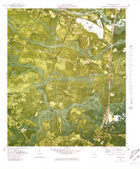 1980 Riceboro1980 Print · USGSThe Georgia coastal lowcountry near the Liberty and McIntosh county line comes into focus during the late seventies. Researchers can trace rural lineages through sites like First African Ch, the Panda Cem, and old rail stops at Brewsters Siding.
 - 1981 Map of Jesup, 1982 Print
 1981 Jesup1982 Print · USGSCoastal Georgia in the early eighties shows a landscape of expansive river deltas and military reservations stretching from the interior to the Atlantic. Genealogists and local historians can trace family locations near Jesup, the old port of Sunbury, or the tidal reaches of the Altamaha River.
 - 1981 Map of Savannah, 1982 Print
 1981 Savannah1982 Print · USGSCoastal Georgia and the South Carolina borderlands are captured here in the early eighties, showing the region's complex network of riverine islands and military installations. Researchers can trace the rail lines of the Central of Georgia and explore sites like Fort Stewart Military Reservation and Garden City.
End of results
Showing maps 1-3 of 3
Top cities of Long County
Frequently asked questions
- What are the different types of historical maps available for Long County?
- What is the oldest map of Long County?
- Where can I purchase historical maps of Long County for my home or office?
- Where can I download high-res historical maps of Long County?
- Are there historical topographic maps available for Long County?
- Is there historical aerial imagery available for Long County?
- Where are historical maps of Long County sourced from?