Old Maps of Long County, Georgia for Academic Research
Study the evolution of Long County with 124 high-resolution historic maps. Whether you're teaching, researching, or modeling changes in land use, these maps provide essential visual documentation of urban, environmental, and geographic change.
- Analyze long-term change: Track patterns in development, transportation, and natural features.
- Ideal for environmental or urban studies: Support academic projects with primary historical map data.
- Use in the classroom or lab: Educators and researchers rely on these maps to bring historical context to life.
These maps are a powerful tool for teaching, research, and visualizing how Long County has changed over the decades.
Long County, GA maps
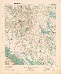
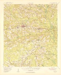
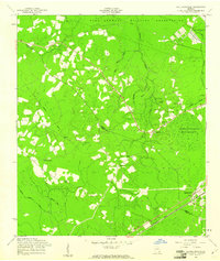
(124)- 1918 Map of Jesup
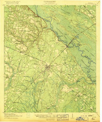 1918 Jesup1918 Print · USGSWayne County was a bustling rail and river corridor during the First World War era. Genealogists can trace family roots through a dense network of local landmarks, from Millikin Crossing School to the rural Bethlehem Church and Midway Church.3 unique versions available
 - 1918 Map of Hinesville
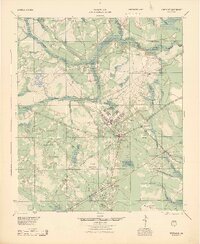
 1918 Hinesville1918 Print · USGSCoastal Liberty County is seen here during World War I, when a network of swamp-skirting roads connected small farming hubs and rail depots. Family historians can trace the exact locations of many rural institutions, including the Liberty Campmeeting Ground, New Jerusalem Church, and Ways Millpond.4 unique versions available
 - 1919 Map of Claxton
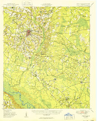
 1919 Claxton1919 Print · USGSSoutheast Georgia rail towns thrive along the Seaboard Air Line just after the Great War, showing a landscape shaped by timber and local agriculture. Genealogists can locate over twenty rural schools and crossings like Deans Crossing, Liberia School, and Hagan.3 unique versions available
 - 1920 Map of Glennville
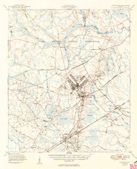
 1920 Glennville1920 Print · USGSSoutheast Georgia in the years after the Great War shows a landscape of rail-connected timber towns and dozens of country schools. Genealogists can locate family landmarks like Vance School, trace the winding Altamaha River past Beards Bluff, or find old crossings like Flat Ford Bridge.3 unique versions available
 - 1920 Map of Sapelo River
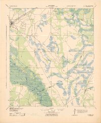
 1920 Sapelo River1920 Print · USGSCoastal McIntosh and Liberty counties were a network of tidal rivers and timber-line railroads during the early twentieth century. Genealogists and historians can trace rail stops like Brewsters Siding, the winding course of the Julienton River, and the landing at Sutherland Bluff.
 - 1943 Map of Ludowici
 1943 Ludowici1943 Print · USGSCoastal Georgia in the early 1940s is defined by the winding Altamaha River and the vital rail junctions at Ludowici. Family historians can trace rural settlements like Bobtown and Upper Sensavilla or locate unique landmarks like the Wreck of Louise.4 unique versions available
 - 1943 Map of Jesup
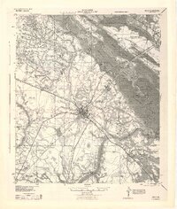 1943 Jesup1943 Print · USGSSoutheast Georgia during the war years reveals a landscape of thriving rail junctions and river landings. Genealogists and local historians can trace the foundations of Wayne County through sites like Redland P O Nesbitt Station, Midway Ch, and Doctortown.
 - 1943 Map of Sapelo River, 1964 Print
 1943 Sapelo River1964 Print · USGSCoastal McIntosh and Liberty counties appear here during the mid-century, defined by a labyrinth of tidal waterways and remote island settlements. Researchers can trace the legacy of old rail stops and road junctions like Warsaw, Brewsters Siding, and Eulonia Station.
 - 1944 Map of Claxton
 1944 Claxton1944 Print · USGSSoutheast Georgia was undergoing significant change in the 1940s as military expansion met established rail towns and rural school districts. Genealogists and historians can trace the footprint of Camp Stewart alongside family-named landmarks like Beasley Sch, Moodys Crossing, and Brewton Mill Sch.
 - 1944 Map of Glennville
 1944 Glennville1944 Print · USGSGlennville and the surrounding Georgia coastal plain are captured during the mid-1940s, showing a landscape defined by small farming communities and river commerce. Genealogists can trace family footprints through numerous local landmarks like Howard Chapel, Mendes, and the Rye Patch School.
 - 1944 Map of Hinesville, 1945 Print
 1944 Hinesville1945 Print · USGSLiberty County underwent a massive transition during the Second World War as military expansion met deep-rooted rural communities. Researchers can trace the layout of Camp Stewart alongside historic landmarks like the Liberty Campmeeting Ground and Providence Sch.
 - 1945 Map of Sapelo River
 1945 Sapelo River1945 Print · USGSCoastal Georgia in the mid-1940s reveals a landscape of tidal rivers and strategic military outposts. Genealogists and historians can trace rail-side settlements like Brewsters Siding and Eulonia Station or locate the Harris Neck Bombing Range and Crescent Station PO.
 - 1946 Map of Brunswick, 1948 Print
 1946 Brunswick1948 Print · USGSCoastal Georgia in the mid-forties reveals a landscape defined by the Camp Stewart Military Reservation and the sprawling barrier islands. Genealogists and historians can trace the rail-and-river network through inland towns like Ludowici and Jesup, or locate coastal landmarks like the St Simon Light.
 - 1947 Map of Savannah
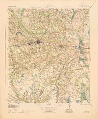
 1947 Savannah1947 Print · USGSCoastal Georgia and South Carolina are captured here in the mid-forties, showing the rail-and-river networks of the Lowcountry. Genealogists and researchers can trace old crossroads and river towns from Statesboro to Beaufort, alongside military sites like Camp Stewart and Parris Island.
 - 1948 Map of Brunswick
 1948 Brunswick1948 Print · USGSCoastal Georgia in the late 1940s is defined here by its labyrinthine barrier islands and the massive footprint of Camp Stewart. Genealogists and historians can trace the rail-tied growth of Jesup and Hinesville or locate coastal landmarks like St Simon Light.
 - 1948 Map of Savannah
 1948 Savannah1948 Print · USGSThe Georgia and South Carolina Lowcountry comes alive in this post-war survey of the coast and its river-fed hinterlands. Genealogists and historians can trace rail lines like the Central of Georgia RR and find established settlements such as Isle of Hope and Sylvania.
 - 1950 Map of Glennville
 1950 Glennville1950 Print · USGSGlennville and the surrounding Tattnall County timberlands are captured here at mid-century as the local economy balanced millpond industry with a growing military presence. Researchers can trace rural life through scattered landmarks like Smiley Crossroads, Donald, and the Rye Patch Sch.2 unique versions available
 - 1950 Map of Hinesville
 1950 Hinesville1950 Print · USGSLiberty County was undergoing a major transformation at mid-century as the military footprint grew around Hinesville. Genealogists and historians can trace the foundations of this change through landmarks like Terrells Millpond, Providence School, and the Cypress Slash Cem.2 unique versions available
 - 1950 Map of Claxton
 1950 Claxton1950 Print · USGSMid-century Evans County centers on the thriving rail corridor connecting Claxton, Hagan, and Daisy during the height of the Seaboard Air Line era. Genealogists and historians can locate numerous rural landmarks like the Ennis Branch School, Sikes Chapel, and the vast Camp Stewart Military Reservation.2 unique versions available
 - 1955 Map of Riceboro, 1959 Print
 1955 Riceboro1959 Print · USGSCoastal Georgia in the mid-fifties is defined here by the intersection of the Seaboard Air Line Railroad and the vast marshlands of Liberty and McIntosh Counties. Researchers can locate community centers like Riceboro, the First African Ch, and long-standing family landmarks such as Pando Cem.2 unique versions available
 - 1956 Map of Brunswick, 1968 Print
 1956 Brunswick1968 Print · USGSThe Georgia coast in the mid-twentieth century is a wild expanse of barrier islands and massive river deltas. You can trace the development of the maritime economy and military presence at Brunswick, or locate historic sites like Fort Frederica National Monument and Harris Neck National Wildlife Refuge.2 unique versions available
 - 1957 Map of Savannah, 1967 Print
 1957 Savannah1967 Print · USGSThe Lowcountry and Georgia coastal plain are shown here in the late fifties, prior to modern expansion. Researchers can trace the rail-and-river economy through the Central of Georgia lines and the Ogeechee River wetlands.4 unique versions available
 - 1958 Map of Glennville NE, 1961 Print
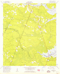
 1958 Glennville NE1961 Print · USGSCoastal Georgia's rural landscape is seen here during the late 1950s as military boundaries reshaped the backcountry of Long and Liberty Counties. Genealogists can trace several vanished church sites and cemeteries including Poplar Head Cem, Smith Chapel Cem, and New Bethel Ch.2 unique versions available
 - 1958 Map of Taylors Creek, 1961 Print
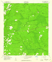
 1958 Taylors Creek1961 Print · USGSLiberty and Long County terrain is documented here in the late fifties as the military expanded its footprint. Genealogists can trace family burial grounds like Todd-Ray Cem and Taylors Creek Cem or follow the path of an Old Railroad Grade.3 unique versions available
 - 1958 Map of Walthourville, 1961 Print
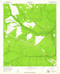
 1958 Walthourville1961 Print · USGSLiberty and Long Counties in the late fifties show the transition from rural farming communities to military land use. Genealogists and historians can locate old rural landmarks like Elim Ch, Wells Cem, and the waters of Terrells Millpond.2 unique versions available
Showing maps 1-25 of 124
Top cities of Long County
Frequently asked questions
- What are the different types of historical maps available for Long County?
- What is the oldest map of Long County?
- Where can I purchase historical maps of Long County for my home or office?
- Where can I download high-res historical maps of Long County?
- Are there historical topographic maps available for Long County?
- Is there historical aerial imagery available for Long County?
- Where are historical maps of Long County sourced from?