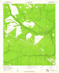
1958 Map of Taylors Creek
USGS Topo · Published 1961About this map
Canoochee Creek and Taylors Creek dominate this landscape within the boundaries of the Fort Stewart Military Reservation. The map captures a transition where natural drainage systems like Sandy Swamp and Strum Bay define the low-lying terrain of the Georgia coastal plain. Notable for local historians and genealogists are the isolated burial sites, including Todd-Ray Cem and Taylors Creek Cem, which remain within the military borders alongside several unnamed cemeteries.
Find a feature on this map
20 named features on this map. Tap any name to fly to it.
Don’t see what you’re looking for? This feature index may not catch every label — zoom into the map to look around manually.
Map Details
Editions of this 1958 Taylors Creek Map
3 editions found
Other maps of this area

1918 · Hinesville
USGS Topo · 1:62,500

1919 · Claxton
USGS Topo · 1:62,500

1920 · Pembroke
USGS Topo · 1:62,500

1920 · Glennville
USGS Topo · 1:62,500

1944 · Claxton
USGS Topo · 1:62,500

1944 · Glennville
USGS Topo · 1:62,500

1944 · Hinesville
USGS Topo · 1:62,500

1946 · Brunswick
USGS Topo · 1:250,000

1947 · Savannah
USGS Topo · 1:250,000

1948 · Brunswick
USGS Topo · 1:250,000