1990s Maps of Lowndes County, Georgia
Explore 3 historic maps of Lowndes County from the 1990s. These maps offer a rare glimpse into what life looked like during the 1990s — showing old roads, neighborhoods, homes, and landmarks that have changed or disappeared over time.
Whether you're researching your family's past, planning a metal detecting trip, or studying how Lowndes County's landscape evolved across the 1990s, these high-resolution maps are a powerful tool for exploring the history of this region.
- Focus on a specific era: All maps on this page are from the 1990s, giving you a focused view of this time period.
- See what’s changed: Compare century-old streets, trails, and buildings to today's modern landscape using overlays and satellite layers.
- Research with precision: Use these maps for genealogy, historical research, land use analysis, or educational projects.
- View, download, or print: Maps are fully viewable online in high resolution, and can be downloaded or printed for your own records.
Start exploring Lowndes County's history through authentic maps from the 1990s. This is your window into the past.
Lowndes County, GA maps
(3)- 1994 Map of Lake Park, 1998 Print
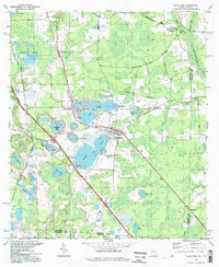 1994 Lake Park1998 Print · USGSThe Georgia-Florida border country near Lowndes County is captured here in the mid-nineties, showing a landscape defined by deep blue sinkhole lakes. Researchers can trace local history at Lake Park Cem, Strickland Ch, and the waters of Ocean Pond.
 - 1994 Map of Nankin, 1998 Print
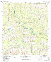 1994 Nankin1998 Print · USGSThe Georgia-Florida borderlands come into focus in the mid-1990s as the Withlacoochee River winds through Brooks County. Genealogists can trace a dense network of country churches and cemeteries, from Nankin to Silver Run Ch and Redland Cem.
 - 1994 Map of Clyattville, 1998 Print
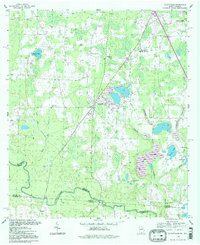 1994 Clyattville1998 Print · USGSIn the mid-1990s, the Georgia-Florida borderlands near the Withlacoochee River remained a landscape of scattered rural communities and extensive wetlands. Researchers can trace the layout of community hubs like Clyattville while locating local landmarks such as Forest Grove Cemetery and Ochlawilla Ch.2 unique versions available
End of results
Showing maps 1-3 of 3
Top cities of Lowndes County
- Valdosta historical maps
- Hahira historical maps
- Remerton historical maps
- Dasher historical maps
- Lake Park historical maps
Frequently asked questions
- What are the different types of historical maps available for Lowndes County?
- What is the oldest map of Lowndes County?
- Where can I purchase historical maps of Lowndes County for my home or office?
- Where can I download high-res historical maps of Lowndes County?
- Are there historical topographic maps available for Lowndes County?
- Is there historical aerial imagery available for Lowndes County?
- Where are historical maps of Lowndes County sourced from?