1900s (20th Century) Maps of Valdosta, Georgia
Explore 8 historic maps of Valdosta from the 1900s (20th Century). These maps offer a rare glimpse into what life looked like during the 1900s — showing old roads, neighborhoods, homes, and landmarks that have changed or disappeared over time.
Whether you're researching your family's past, planning a metal detecting trip, or studying how Valdosta's landscape evolved across the 1900s, these high-resolution maps are a powerful tool for exploring the history of this region.
- Focus on a specific era: All maps on this page are from the 1900s, giving you a focused view of this time period.
- See what’s changed: Compare century-old streets, trails, and buildings to today's modern landscape using overlays and satellite layers.
- Research with precision: Use these maps for genealogy, historical research, land use analysis, or educational projects.
- View, download, or print: Maps are fully viewable online in high resolution, and can be downloaded or printed for your own records.
Start exploring Valdosta's history through authentic maps from the 1900s. This is your window into the past.
Valdosta, GA maps
(8)- 1954 Map of Valdosta, 1967 Print
 1954 Valdosta1967 Print · USGSThe South Georgia and North Florida borderlands are captured here in the mid-fifties, showing the deep timber and wetland networks of the coastal plain. Researchers can trace the path of the Atlantic Coast Line through Valdosta or explore the interior of the Okefenokee Swamp.2 unique versions available
 - 1958 Map of Valdosta
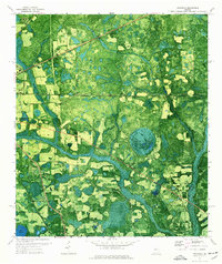
 1958 Valdosta1958 Print · USGSSouth Georgia and North Florida are captured here in the mid-fifties, showing the vast Okefenokee Swamp and the vital timber and rail corridors connecting the two states. Researchers can locate the footprint of Moody Air Force Base, trace the Live Oak Perry and Gulf railroad, or find early community sites like Bakers Mill and Paradise Church.
 - 1959 Map of Valdosta
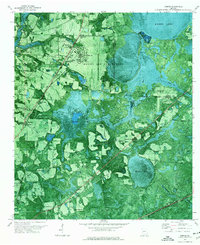
 1959 Valdosta1959 Print · USGSThe Georgia-Florida borderlands in the mid-fifties reveal a landscape of massive blackwater swamps and emerging military aviation hubs. Genealogists and historians can trace rail-stop towns like Fargo and Stockton or explore the interior reaches of the Okefenokee Swamp and Billys Island.
 - 1961 Map of Hahira East, 1964 Print
 1961 Hahira East1964 Print · USGSIn the early sixties, this area north of Valdosta shows a landscape of traditional agriculture beginning to meet modern highway development. Genealogists can locate family landmarks like Passmore Cem, Jerusalem Ch, and the rural community at Mineola.4 unique versions available
 - 1961 Map of Valdosta, 1965 Print
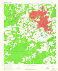 1961 Valdosta1965 Print · USGSValdosta and its surrounding Lowndes County communities are captured in the early sixties as a thriving center of Georgia education and industry. Researchers can trace the footprints of Valdosta State College, locate family sites near Riverhill Cem, or follow the ATLANTIC COAST LINE through West Valdosta.4 unique versions available
 - 1971 Map of Indianola, 1976 Print
 1971 Indianola1976 Print · USGSSouth Georgia's rural landscape is captured here in the early 1970s as two major railroads intersect near the Florida border. Genealogists and local historians can trace the foundations of Indianola and Dasher alongside rural landmarks like Twin Hill Ch and Boring Pond.
 - 1971 Map of Bemiss, 1976 Print
 1971 Bemiss1976 Print · USGSLowndes County enters the early seventies as a hub of military aviation and rural southern tradition. Trace the development around Moody Air Force Base or locate family roots at Antioch Cem and schools like Pine Grove Sch.
 - 1981 Map of Valdosta
 1981 Valdosta1981 Print · USGSCrossing the Georgia and Florida border in the early eighties, this survey captures the agricultural and military landscape of the coastal plain. Genealogists and historians can trace the rail-linked growth of Valdosta and Quitman or find rural landmarks like New Hope Church and Lake Miccosukee.
End of results
Showing maps 1-8 of 8
Top cities near Valdosta
- Lakeland historical maps
- Hahira historical maps
- Remerton historical maps
- Dasher historical maps
- Ray City historical maps
- Jennings historical maps
See more
Top neighborhoods of Valdosta
- Cherry Creek Hills historical maps
- Eastwind historical maps
- Charter Oaks historical maps
- Eager historical maps
- Five Points historical maps
- Wood Valley historical maps
See more
Frequently asked questions
- What are the different types of historical maps available for Valdosta?
- What is the oldest map of Valdosta?
- Where can I purchase historical maps of Valdosta for my home or office?
- Where can I download high-res historical maps of Valdosta?
- Are there historical topographic maps available for Valdosta?
- Is there historical aerial imagery available for Valdosta?
- Where are historical maps of Valdosta sourced from?