1950s Maps of Darien, Georgia
Explore 4 historic maps of Darien from the 1950s. These maps offer a rare glimpse into what life looked like during the 1950s — showing old roads, neighborhoods, homes, and landmarks that have changed or disappeared over time.
Whether you're researching your family's past, planning a metal detecting trip, or studying how Darien's landscape evolved across the 1950s, these high-resolution maps are a powerful tool for exploring the history of this region.
- Focus on a specific era: All maps on this page are from the 1950s, giving you a focused view of this time period.
- See what’s changed: Compare century-old streets, trails, and buildings to today's modern landscape using overlays and satellite layers.
- Research with precision: Use these maps for genealogy, historical research, land use analysis, or educational projects.
- View, download, or print: Maps are fully viewable online in high resolution, and can be downloaded or printed for your own records.
Start exploring Darien's history through authentic maps from the 1950s. This is your window into the past.
Darien, GA maps
(4)- 1954 Map of Altamaha Sound, 1959 Print
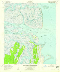 1954 Altamaha Sound1959 Print · USGSThe Georgia coast at the edge of the Atlantic was a labyrinth of tidal marshes and remote island outposts in the mid-1950s. Genealogists and coastal historians can trace early landmarks like Butler Point, the winding Intracoastal Waterway, and the pristine stretches of the Wolf Island National Wildlife Refuge.2 unique versions available
 - 1954 Map of Ridgeville, 1959 Print
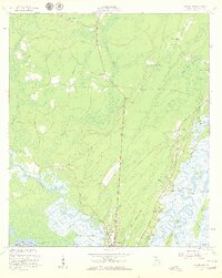 1954 Ridgeville1959 Print · USGSCoastal Georgia in the mid-fifties is captured here during a time of river-based commerce and quiet marshland settlements. Genealogists and historians can trace family locations through St Andrews Cem, the Tolomato Spanish Mission Ruins, and small communities like Ardick and Ashintilly.2 unique versions available
 - 1956 Map of Darien, 1959 Print
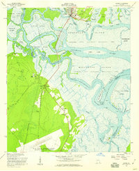 1956 Darien1959 Print · USGSCoastal Georgia's river delta and the historic port of Darien are captured here in the mid-fifties, showing a landscape defined by tidewater islands and colonial ruins. Genealogists and historians can trace the Brunswick-Altamaha Canal, family burial grounds like Butler Cem, and the Santo Domingo Mission Ruins.2 unique versions available
 - 1956 Map of Brunswick, 1968 Print
 1956 Brunswick1968 Print · USGSThe Georgia coast in the mid-twentieth century is a wild expanse of barrier islands and massive river deltas. You can trace the development of the maritime economy and military presence at Brunswick, or locate historic sites like Fort Frederica National Monument and Harris Neck National Wildlife Refuge.2 unique versions available
End of results
Showing maps 1-4 of 4
Top cities near Darien
Top neighborhoods of Darien
Frequently asked questions
- What are the different types of historical maps available for Darien?
- What is the oldest map of Darien?
- Where can I purchase historical maps of Darien for my home or office?
- Where can I download high-res historical maps of Darien?
- Are there historical topographic maps available for Darien?
- Is there historical aerial imagery available for Darien?
- Where are historical maps of Darien sourced from?