1990s Maps of Darien, Georgia
Explore 3 historic maps of Darien from the 1990s. These maps offer a rare glimpse into what life looked like during the 1990s — showing old roads, neighborhoods, homes, and landmarks that have changed or disappeared over time.
Whether you're researching your family's past, planning a metal detecting trip, or studying how Darien's landscape evolved across the 1990s, these high-resolution maps are a powerful tool for exploring the history of this region.
- Focus on a specific era: All maps on this page are from the 1990s, giving you a focused view of this time period.
- See what’s changed: Compare century-old streets, trails, and buildings to today's modern landscape using overlays and satellite layers.
- Research with precision: Use these maps for genealogy, historical research, land use analysis, or educational projects.
- View, download, or print: Maps are fully viewable online in high resolution, and can be downloaded or printed for your own records.
Start exploring Darien's history through authentic maps from the 1990s. This is your window into the past.
Darien, GA maps
(3)- 1993 Map of Altamaha Sound, 1995 Print
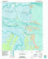 1993 Altamaha Sound1995 Print · USGSCoastal Georgia's barrier islands and river deltas are documented here in the early nineties, showing the meeting of fresh and salt water. Genealogists and historians can locate Hampton Plantation, the Cannons Point ruins, and the path of Lawrence Road.
 - 1993 Map of Ridgeville, 1995 Print
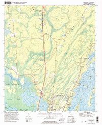 1993 Ridgeville1995 Print · USGSCoastal McIntosh County is captured here in the early nineties, showing a landscape defined by tidal rivers and marshy islands. Genealogists can trace family names and local history through numerous landmarks like Ardoch Cem, Sams Memorial Ch, and Hutchison Cem.2 unique versions available
 - 1993 Map of Darien, 1995 Print
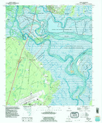 1993 Darien1995 Print · USGSThe Altamaha River delta near the McIntosh and Glynn county line shows a landscape shaped by coastal history and conservation in the mid-1990s. Researchers can trace deep local roots at the Old Slave Cem, Needwood Ch, and the Hofwyl-Broadfield Plantation State Historic Site.
End of results
Showing maps 1-3 of 3
Top cities near Darien
Top neighborhoods of Darien
Frequently asked questions
- What are the different types of historical maps available for Darien?
- What is the oldest map of Darien?
- Where can I purchase historical maps of Darien for my home or office?
- Where can I download high-res historical maps of Darien?
- Are there historical topographic maps available for Darien?
- Is there historical aerial imagery available for Darien?
- Where are historical maps of Darien sourced from?