1970s Maps of Madison, Georgia
Explore 2 historic maps of Madison from the 1970s. These maps offer a rare glimpse into what life looked like during the 1970s — showing old roads, neighborhoods, homes, and landmarks that have changed or disappeared over time.
Whether you're researching your family's past, planning a metal detecting trip, or studying how Madison's landscape evolved across the 1970s, these high-resolution maps are a powerful tool for exploring the history of this region.
- Focus on a specific era: All maps on this page are from the 1970s, giving you a focused view of this time period.
- See what’s changed: Compare century-old streets, trails, and buildings to today's modern landscape using overlays and satellite layers.
- Research with precision: Use these maps for genealogy, historical research, land use analysis, or educational projects.
- View, download, or print: Maps are fully viewable online in high resolution, and can be downloaded or printed for your own records.
Start exploring Madison's history through authentic maps from the 1970s. This is your window into the past.
Madison, GA maps
(2)- 1972 Map of Rutledge South, 1974 Print
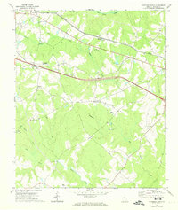 1972 Rutledge South1974 Print · USGSMorgan County is shown in the early seventies as a rural landscape of scattered communities and creek-fed bottomlands. Genealogists and historians can trace family locations through numerous landmarks like Macedonia Ch, Clack Bridge, and Monleys Chapel.2 unique versions available
 - 1972 Map of Madison, 1974 Print
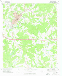 1972 Madison1974 Print · USGSMadison and its rural surroundings are captured in the early 1970s, showcasing a landscape where traditional rail-lines meet modern development. Genealogists and historians can trace numerous rural congregations like Smyrna Ch and schools such as Pearl Jr High Sch.2 unique versions available
End of results
Showing maps 1-2 of 2
Top cities near Madison
- Monroe historical maps
- Eatonton historical maps
- Social Circle historical maps
- Rutledge historical maps
- Newborn historical maps
- Bostwick historical maps
See more
Top neighborhoods of Madison
Frequently asked questions
- What are the different types of historical maps available for Madison?
- What is the oldest map of Madison?
- Where can I purchase historical maps of Madison for my home or office?
- Where can I download high-res historical maps of Madison?
- Are there historical topographic maps available for Madison?
- Is there historical aerial imagery available for Madison?
- Where are historical maps of Madison sourced from?