1960s Maps of Pierce County, Georgia
Explore 3 historic maps of Pierce County from the 1960s. These maps offer a rare glimpse into what life looked like during the 1960s — showing old roads, neighborhoods, homes, and landmarks that have changed or disappeared over time.
Whether you're researching your family's past, planning a metal detecting trip, or studying how Pierce County's landscape evolved across the 1960s, these high-resolution maps are a powerful tool for exploring the history of this region.
- Focus on a specific era: All maps on this page are from the 1960s, giving you a focused view of this time period.
- See what’s changed: Compare century-old streets, trails, and buildings to today's modern landscape using overlays and satellite layers.
- Research with precision: Use these maps for genealogy, historical research, land use analysis, or educational projects.
- View, download, or print: Maps are fully viewable online in high resolution, and can be downloaded or printed for your own records.
Start exploring Pierce County's history through authentic maps from the 1960s. This is your window into the past.
Pierce County, GA maps
(3)- 1961 Map of Brunswick
 1961 Brunswick1961 Print · USGSThe Georgia coast at the start of the 1960s was a landscape of deep tidal marshes and growing military installations. Genealogists and historians can trace rail-linked towns like Limerick Station or explore coastal landmarks from Fort Frederica National Monument to Sapelo Island.
 - 1967 Map of Hoboken West, 1969 Print
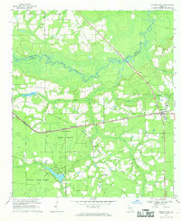 1967 Hoboken West1969 Print · USGSBrantley and Ware counties are shown in the late 1960s, a period defined by the timber industry and the railroad's path through the pine flatwoods. Genealogists can trace family names through numerous rural landmarks like Thrift Cem, St Johns Ch, and the community of Schlatterville.2 unique versions available
 - 1967 Map of Waycross East, 1969 Print
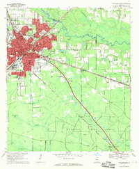 1967 Waycross East1969 Print · USGSWaycross during the late sixties was a thriving railway and educational center at the edge of the Georgia wetlands. Genealogists and historians can trace neighborhood growth through dozens of named schools and cemeteries like Hazzard Hill Cem and Oakland Cemetery.
End of results
Showing maps 1-3 of 3
Top cities of Pierce County
Frequently asked questions
- What are the different types of historical maps available for Pierce County?
- What is the oldest map of Pierce County?
- Where can I purchase historical maps of Pierce County for my home or office?
- Where can I download high-res historical maps of Pierce County?
- Are there historical topographic maps available for Pierce County?
- Is there historical aerial imagery available for Pierce County?
- Where are historical maps of Pierce County sourced from?