1961 Map of Brunswick
USGS Topo · Published 1961About this map
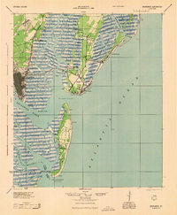
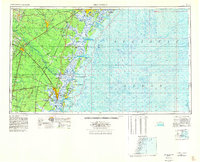
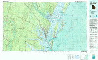
The Georgia coastline and its deep tidal marshes define this 1961 U.S. Geological Survey sheet, centered on the historic port of Brunswick. The intricate network of sounds and islands, from Wassaw Island in the north to Jekyll Island in the south, reveals the complex geography of the Lowcountry. Significant federal and state holdings are prominent, including the sprawling Fort Stewart Military Reservation and the Georgia State Prison Farm. Inland, the landscape is a patchwork of swamps and river systems like the Altamaha River and Buffalo Swamp, which historically dictated the placement of settlements and transport routes.
Find a feature on this map
155 named features on this map. Tap any name to fly to it.
Don’t see what you’re looking for? This feature index may not catch every label — zoom into the map to look around manually.
Map Details
Editions of this 1961 Brunswick Map
This is the sole edition of this map. No revisions or reprints were ever made.
Historical Maps of Savannah Through Time
7 maps found