1970s Maps of Shellman, Georgia
Explore 4 historic maps of Shellman from the 1970s. These maps offer a rare glimpse into what life looked like during the 1970s — showing old roads, neighborhoods, homes, and landmarks that have changed or disappeared over time.
Whether you're researching your family's past, planning a metal detecting trip, or studying how Shellman's landscape evolved across the 1970s, these high-resolution maps are a powerful tool for exploring the history of this region.
- Focus on a specific era: All maps on this page are from the 1970s, giving you a focused view of this time period.
- See what’s changed: Compare century-old streets, trails, and buildings to today's modern landscape using overlays and satellite layers.
- Research with precision: Use these maps for genealogy, historical research, land use analysis, or educational projects.
- View, download, or print: Maps are fully viewable online in high resolution, and can be downloaded or printed for your own records.
Start exploring Shellman's history through authentic maps from the 1970s. This is your window into the past.
Shellman, GA maps
(4)- 1972 Map of Shellman, 1974 Print
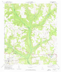 1972 Shellman1974 Print · USGSRandolph and Terrell counties are shown during a period of steady agricultural tradition in the early seventies. Genealogists can trace family footprints across numerous rural landmarks, from Shellman and Graves to Oak Grove Ch and the Sand Hill Cem.
 - 1972 Map of Brooksville, 1974 Print
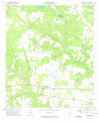 1972 Brooksville1974 Print · USGSRandolph County in the early seventies remained a landscape of quiet rail corridors and scattered rural parishes. Researchers can trace the path of the Central of Georgia railroad through Shellman or locate family landmarks like Pachitla Ch and Lake Marie.
 - 1973 Map of Martins Crossroads, 1975 Print
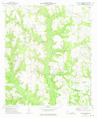 1973 Martins Crossroads1975 Print · USGSRandolph and Calhoun counties are captured in the early seventies, showing a rural landscape defined by family-named landmarks and country churches. Researchers can trace local heritage through sites like Martins Crossroads, Goffs Mill, and the many cemeteries near Jacobs Chapel.
 - 1973 Map of Doverel, 1975 Print
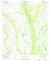 1973 Doverel1975 Print · USGSRandolph and Terrell counties are shown here in the early seventies, a landscape of family farms and creek-side industry. You can trace local roots at Aycock Mill and Collier Cem, or locate rural landmarks like Dover Ch and Five Points.
End of results
Showing maps 1-4 of 4
Top cities near Shellman
- Dawson historical maps
- Cuthbert historical maps
- Morgan historical maps
- Edison historical maps
- Parrott historical maps
- Weston historical maps
Frequently asked questions
- What are the different types of historical maps available for Shellman?
- What is the oldest map of Shellman?
- Where can I purchase historical maps of Shellman for my home or office?
- Where can I download high-res historical maps of Shellman?
- Are there historical topographic maps available for Shellman?
- Is there historical aerial imagery available for Shellman?
- Where are historical maps of Shellman sourced from?