1920s Maps of Screven County, Georgia
Explore 8 historic maps of Screven County from the 1920s. These maps offer a rare glimpse into what life looked like during the 1920s — showing old roads, neighborhoods, homes, and landmarks that have changed or disappeared over time.
Whether you're researching your family's past, planning a metal detecting trip, or studying how Screven County's landscape evolved across the 1920s, these high-resolution maps are a powerful tool for exploring the history of this region.
- Focus on a specific era: All maps on this page are from the 1920s, giving you a focused view of this time period.
- See what’s changed: Compare century-old streets, trails, and buildings to today's modern landscape using overlays and satellite layers.
- Research with precision: Use these maps for genealogy, historical research, land use analysis, or educational projects.
- View, download, or print: Maps are fully viewable online in high resolution, and can be downloaded or printed for your own records.
Start exploring Screven County's history through authentic maps from the 1920s. This is your window into the past.
Screven County, GA maps
(8)- 1920 Map of Ellenton
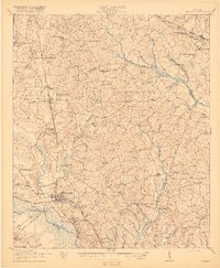
 1920 Ellenton1920 Print · USGSThe Savannah River valley in the years following the Great War reveals a landscape of river landings and small rail towns. Genealogists can trace family footprints through rural sites like Ellenton, St Marys Church, and the Burton and Myers Store.
 - 1920 Map of Hilltonia
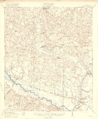
 1920 Hilltonia1920 Print · USGSScreven County and the Savannah River valley are captured here at the end of the Great War, showing a landscape defined by ferries and rail. Genealogists can trace family footprints at Lovetts Cemetery, Bascom School, and the riverfront at Burtons Ferry.4 unique versions available
 - 1920 Map of Millen
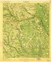
 1920 Millen1920 Print · USGSJenkins County at the start of the twenties shows a landscape defined by the Ogeechee River and the busy rail junction at Millen. Genealogists can trace family footprints across dozens of rural landmarks like Old McCoy Church, Walker Academy, and Magnolia Spring.2 unique versions available
 - 1920 Map of Oliver
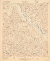
 1920 Oliver1920 Print · USGSScreven County agriculture and river commerce thrived in the years following the Great War. Genealogists can locate family landmarks across the Ogeechee basin, from Double Head Church and Middle Ground School to the bustling rail stops at Halcyondale and Oliver.2 unique versions available
 - 1920 Map of Peeples
 1920 Peeples1920 Print · USGSThe Savannah River lowcountry during the years following the Great War reveals a landscape of river landings and new highways. Genealogists can trace family roots through numerous sites like Virgin Mary Church, Buddenville School, and Solomons Crossroads.3 unique versions available
 - 1921 Map of Brooklet
 1921 Brooklet1921 Print · USGSBulloch County's rural heartland is captured here during the 1920s, showing a landscape defined by small-town rail junctions and river fords. Genealogists can trace family footprints at vanished landmarks like Slabville School, Corinth Church, and Ebenezer Ford.2 unique versions available
 - 1921 Map of Rocky Ford
 1921 Rocky Ford1921 Print · USGSSoutheast Georgia in the early twenties reveals a landscape of river-bottom swamps and decentralized farming communities. Genealogists can trace local roots through numerous family-named landmarks like Bradwell School, Akins Mill Creek, and Finchs Store.2 unique versions available
 - 1921 Map of Ellenton
 1921 Ellenton1921 Print · USGSThe Savannah River valley in the early 1920s reveals a lost network of riverside landings and agricultural rail stops. Genealogists can trace family footprints at Ellenton, Meyers Mill, and rural sites like Friendship Church or Bethesda School.2 unique versions available
End of results
Showing maps 1-8 of 8
Top cities of Screven County
- Sylvania historical maps
- Hiltonia historical maps
- Newington historical maps
- Oliver historical maps
- Rocky Ford historical maps
Frequently asked questions
- What are the different types of historical maps available for Screven County?
- What is the oldest map of Screven County?
- Where can I purchase historical maps of Screven County for my home or office?
- Where can I download high-res historical maps of Screven County?
- Are there historical topographic maps available for Screven County?
- Is there historical aerial imagery available for Screven County?
- Where are historical maps of Screven County sourced from?