1980s Maps of Screven County, Georgia
Explore 3 historic maps of Screven County from the 1980s. These maps offer a rare glimpse into what life looked like during the 1980s — showing old roads, neighborhoods, homes, and landmarks that have changed or disappeared over time.
Whether you're researching your family's past, planning a metal detecting trip, or studying how Screven County's landscape evolved across the 1980s, these high-resolution maps are a powerful tool for exploring the history of this region.
- Focus on a specific era: All maps on this page are from the 1980s, giving you a focused view of this time period.
- See what’s changed: Compare century-old streets, trails, and buildings to today's modern landscape using overlays and satellite layers.
- Research with precision: Use these maps for genealogy, historical research, land use analysis, or educational projects.
- View, download, or print: Maps are fully viewable online in high resolution, and can be downloaded or printed for your own records.
Start exploring Screven County's history through authentic maps from the 1980s. This is your window into the past.
Screven County, GA maps
(3)- 1981 Map of Savannah, 1982 Print
 1981 Savannah1982 Print · USGSCoastal Georgia and the South Carolina borderlands are captured here in the early eighties, showing the region's complex network of riverine islands and military installations. Researchers can trace the rail lines of the Central of Georgia and explore sites like Fort Stewart Military Reservation and Garden City.
 - 1981 Map of Sylvania, 1982 Print
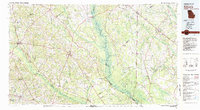 1981 Sylvania1982 Print · USGSThe Georgia and South Carolina borderlands appear in the early 1980s, centered on the river-fed swamps and railroad towns between Sylvania and Estill. Trace family roots and vanished infrastructure along the Central of Georgia line or near Magnolia Springs State Park.
 - 1982 Map of Barnwell, 1984 Print
 1982 Barnwell1984 Print · USGSCoastal plain settlements and a massive nuclear infrastructure meet in South Carolina during the early eighties. Genealogists and historians can trace rail-town development along the Southern line and explore the footprint of the Savannah River Plant Department of Energy.
End of results
Showing maps 1-3 of 3
Top cities of Screven County
- Sylvania historical maps
- Hiltonia historical maps
- Newington historical maps
- Oliver historical maps
- Rocky Ford historical maps
Frequently asked questions
- What are the different types of historical maps available for Screven County?
- What is the oldest map of Screven County?
- Where can I purchase historical maps of Screven County for my home or office?
- Where can I download high-res historical maps of Screven County?
- Are there historical topographic maps available for Screven County?
- Is there historical aerial imagery available for Screven County?
- Where are historical maps of Screven County sourced from?